Category: Geography

  • Turkiye’s Neighbors and Geographic Location

    Turkey is a unique country located at the crossroads of Europe and Asia, connecting two continents through its strategic geographic position. The country’s location has shaped its history, culture, economy, and role as a bridge between different civilizations for thousands of years.

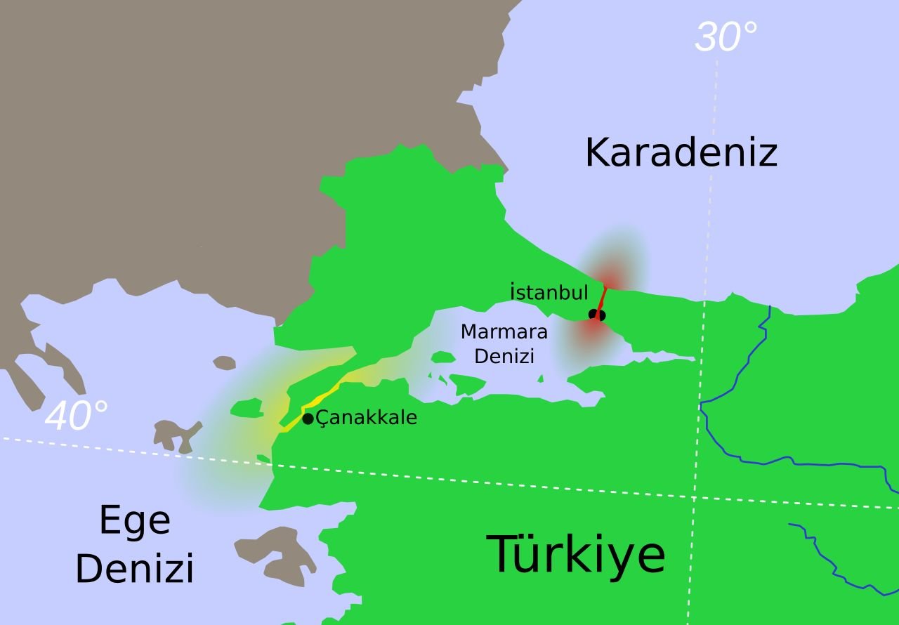
    Approximately 97% of Turkey’s territory lies in Asia (Anatolia), while around 3% is located in Europe (Eastern Thrace). These two parts are separated by a remarkable series of waterways: the Bosphorus Strait (İstanbul Boğazı), the Sea of Marmara, and the Dardanelles Strait (Çanakkale Boğazı).

    Size and Geography of Turkey

    Turkey covers approximately 783,562 square kilometers of land area, making it one of the largest countries in both Europe and the Middle East.

    To provide a comparison, Turkey is:

    • About 15 times larger than the Netherlands
    • Larger than many European countries combined
    • Similar in size to countries such as Chile or Zambia

    The country’s diverse geography includes:

    • High mountains
    • Fertile plains
    • Forest regions
    • Long coastal areas
    • Lakes and rivers
    • Semi-arid landscapes

    This geographical diversity creates a wide range of climates and ecosystems.

    Seas Surrounding Turkey

    Turkey is surrounded by four important seas, each contributing to the country’s natural beauty, economy, and tourism appeal:

    Black Sea (North)

    The Black Sea coastline stretches along northern Turkey and is known for:

    • Green mountain landscapes
    • Tea plantations
    • Traditional villages
    • Fishing communities
    • The scenic Black Sea coastal road

    Mediterranean Sea (South)

    The Mediterranean coast is famous for its warm climate, beaches, and tourism centers such as:

    • Antalya
    • Alanya
    • Kaş
    • Kemer
    • Side

    Aegean Sea (West)

    The Aegean coastline is rich in history and natural beauty, featuring:

    • Ancient Greek and Roman ruins
    • Island landscapes
    • Coastal towns such as Izmir, Bodrum, Çeşme, and Fethiye

    Sea of Marmara

    Located between Europe and Asia, the Sea of Marmara connects the Black Sea with the Aegean Sea through the Turkish Straits. It surrounds Istanbul and has great economic and historical importance.

    Turkey has approximately 8,000 kilometers of coastline, providing a remarkable variety of beaches, harbors, islands, and marine ecosystems.

    Turkey’s Neighboring Countries

    Turkey shares land borders with eight countries:

    Northwest

    • Greece – sharing a border in the European region of Thrace
    • Bulgaria – Turkey’s northern European neighbor

    Northeast

    • Georgia – located in the Caucasus region
    • Armenia – Turkey’s eastern neighbor

    East

    • Iran – one of Turkey’s oldest regional neighbors

    Southeast

    • Iraq
    • Syria

    These borders place Turkey at the meeting point of Europe, the Caucasus, the Middle East, and the Mediterranean world.

    Strategic Importance of Turkey’s Location

    Turkey’s geography has given it exceptional strategic importance throughout history. The Turkish Straits, especially the Bosphorus and Dardanelles, are among the world’s most important maritime passages, connecting the Black Sea with global shipping routes.

    This location has influenced:

    • Ancient trade routes
    • The Byzantine and Ottoman empires
    • Modern international commerce
    • Energy transportation corridors
    • Cultural exchange between continents

    Travel Perspective

    For visitors, Turkey’s geographic diversity means that a single country offers many different experiences:

    • Mediterranean beaches and resorts
    • Ancient archaeological sites
    • European-style cities
    • Asian landscapes
    • Mountain villages
    • Unique natural wonders such as Cappadocia and Pamukkale

    Turkey’s position between continents is not only a geographical fact – it is the foundation of the country’s extraordinary cultural and natural richness.

  • The Sea of Marmara, Turkiye: The Inland Sea Between Europe and Asia

    The Sea of Marmara is one of Turkey’s most unique geographical features and the only inland sea located entirely within the country. Positioned between Europe and Asia, it forms a natural connection between the Black Sea and the Aegean Sea, separating the European region of Thrace from the Asian region of Anatolia.

    For thousands of years, the Sea of Marmara has been a vital maritime crossroads, influencing trade routes, military campaigns, migrations, and the development of some of history’s greatest civilizations. Today, it remains an important transportation route as well as a popular destination for tourism, sailing, fishing, and coastal exploration.


    Geography and Location of the Sea of Marmara

    The Sea of Marmara is connected:

    • To the Black Sea through the Bosporus Strait
    • To the Aegean Sea through the Dardanelles Strait

    Together, the Bosporus, Sea of Marmara, and Dardanelles form the Turkish Straits system, one of the world’s most strategically important waterways.

    The Bosporus divides Istanbul, Turkey’s largest city, into two continents:

    • The European side (Thrace)
    • The Asian side (Anatolia)

    This unique position makes Istanbul one of the few cities in the world located on two continents.


    Size and Physical Characteristics

    The Sea of Marmara covers approximately:

    • Area: 11,350 square kilometres
    • Length: About 280 kilometres from east to west
    • Maximum width: Around 80 kilometres
    • Maximum depth: Approximately 1,370 metres

    Although much smaller than Turkey’s surrounding seas, the Marmara Sea has exceptional geographic importance because it controls maritime access between the Black Sea and the Mediterranean region.


    Water Characteristics and Marine Environment

    The Sea of Marmara has a unique two-layer water system.

    The surface waters have an average salinity of around 22 parts per thousand, making them:

    • More saline than the Black Sea
    • Less saline than the Mediterranean Sea

    At deeper levels, salinity rises to approximately 38 parts per thousand, similar to Mediterranean waters.

    Because the deep water is denser, it remains below the surface and mixes only slowly with upper layers. This creates a special marine ecosystem with different conditions at various depths.


    Rivers Flowing into the Sea of Marmara

    Several rivers contribute freshwater to the Marmara basin.

    Important rivers include:

    • Biga River
    • Gönen River
    • Susurluk River
    • Kocabaş River (ancient Granicus)

    Most of these rivers originate in Anatolia. Since the Thrace region has fewer large rivers flowing southward, the freshwater contribution mainly comes from the Asian side.

    The rivers have historically supported fertile agricultural areas around Bursa, Balıkesir, and Çanakkale.


    The Islands of the Sea of Marmara

    The Sea of Marmara contains two important island groups that have played significant roles throughout history.


    The Princes’ Islands (Adalar)

    Located close to Istanbul, the Princes’ Islands are among Turkey’s most popular island destinations.

    The group consists of several islands, including:

    • Büyükada
    • Heybeliada
    • Burgazada
    • Kınalıada

    The islands are famous for:

    • Historic wooden mansions
    • Pine forests
    • Peaceful atmosphere
    • Horse-drawn carriages (historically)
    • Cycling routes
    • Sea views of Istanbul

    They provide a relaxing escape from the busy urban environment of Istanbul.


    The Marmara Islands

    Located in the southwestern part of the sea, the Marmara Islands have been famous since antiquity for their marble quarries.

    The name Marmara comes from the ancient Greek word:

    mármaron (μάρμαρον) meaning “marble.”

    The islands supplied high-quality marble used in important buildings throughout the Greek, Roman, Byzantine, and Ottoman periods.

    Today, the islands are known for:

    • Beaches
    • Fishing villages
    • Traditional island life
    • Nature tourism

    Historical Name: Propontis

    In ancient times, the Sea of Marmara was known as Propontis.

    The name comes from ancient Greek:

    • Pro = before
    • Pontos = sea

    Meaning:

    “The sea before the sea.”

    Ancient Greek sailors travelling from the Aegean Sea toward the Black Sea passed through Propontis before reaching the northern waters.

    Because of its strategic position, controlling the Sea of Marmara was essential for ancient powers including:

    • Greeks
    • Persians
    • Romans
    • Byzantines
    • Ottomans

    The Sea of Marmara in Greek Mythology

    The Sea of Marmara appears in one of the most famous stories of Greek mythology: the voyage of the Argonauts.

    According to legend, Jason and the Argonauts encountered a violent storm while crossing the Propontis and were forced back to the island of Cyzicus.

    The heroes were mistaken for enemies by King Cyzicus and his warriors. A tragic battle followed during the night, resulting in the accidental death of the king.

    Different versions of the myth attribute the fatal blow either to:

    • Jason
    • Heracles (Hercules)

    The story remains one of the most memorable legends connected with the ancient Propontis.


    Ancient Cities Around the Sea of Marmara

    The shores of the Sea of Marmara have been home to many important settlements.

    Notable ancient and historic sites include:

    Cyzicus (Kyzikos)

    Located near modern-day Erdek, Cyzicus was one of the most important cities of ancient Mysia.

    It was famous for:

    • The Temple of Hadrian
    • Large harbor facilities
    • Trade connections
    • Marble architecture

    Byzantium

    Founded on the Bosporus, Byzantium later became:

    • Constantinople
    • The capital of the Byzantine Empire
    • Istanbul

    Nicomedia

    Modern İzmit was the capital of the Roman province of Bithynia and later became one of the most important cities of the Eastern Roman Empire.


    Earthquakes and the North Anatolian Fault

    The Sea of Marmara lies above the North Anatolian Fault, one of the most active earthquake zones in the world.

    This fault system has produced many powerful earthquakes throughout history.

    One of the most significant recent events was:

    The 1999 İzmit Earthquake

    which caused extensive damage in the Marmara region.

    Because of this geological activity, earthquake research and preparedness remain important issues for cities around the sea, especially Istanbul.


    Tourism Around the Sea of Marmara

    The Sea of Marmara offers visitors a combination of:

    • History
    • Islands
    • Beaches
    • Nature
    • Sailing
    • Local cuisine
    • Cultural experiences

    Popular destinations include:


    Istanbul Coastline

    The Marmara coastline of Istanbul offers:

    • Bosporus and Marmara cruises
    • Historic neighborhoods
    • Seafood restaurants
    • Waterfront promenades

    Bursa and Mudanya

    Located on the southern coast, Bursa and Mudanya offer:

    • Ottoman heritage
    • Thermal springs
    • Coastal villages
    • Traditional seafood restaurants

    Yalova

    Known for:

    • Thermal springs
    • Green landscapes
    • Forests
    • Weekend tourism from Istanbul

    Balıkesir and Erdek

    The northern shores provide:

    • Beaches
    • Island excursions
    • Fishing villages
    • Nature tourism

    Sailing and Maritime Activities

    The Sea of Marmara is popular for:

    • Yacht cruises
    • Sailing trips
    • Fishing tours
    • Island excursions
    • Coastal exploration

    Its protected waters make it suitable for both experienced sailors and leisure travelers.


    Environmental Challenges

    Despite its importance, the Sea of Marmara faces environmental pressures, including:

    • Urban pollution
    • Industrial waste
    • Overfishing
    • Marine ecosystem changes

    The protection of this unique inland sea has become an important environmental priority for Turkey.


    Discovering the Sea of Marmara

    The Sea of Marmara is much more than a body of water between two continents. It is a place where geography, mythology, history, and modern life meet.

    From the ancient Propontis of Greek sailors to the maritime heart of the Byzantine and Ottoman empires, this inland sea has shaped the destiny of civilizations for more than two thousand years.

    Today, visitors can explore historic islands, ancient ports, coastal towns, and vibrant Istanbul shores while experiencing one of the world’s most fascinating maritime regions – a sea that truly connects Europe and Asia.

  • Turkey’s Forest Villages: Life, Challenges, and Environmental Protection

    Turkey’s forest villages (orman köyleri) are rural settlements located within or near forested areas, especially in the mountainous regions of the Black Sea, Mediterranean, Aegean, and Western Anatolia. These villages have traditionally depended on forests for their livelihoods, using natural resources for agriculture, livestock, construction materials, and heating.

    Life in forest villages is often more challenging than in ordinary rural settlements due to difficult terrain, limited transportation access, and economic disadvantages. At the same time, the relationship between villagers and forests has become an important environmental issue, as traditional practices can sometimes contribute to forest degradation.

    To protect both rural communities and forest ecosystems, the Turkish government has developed various support programs aimed at improving living conditions while encouraging sustainable use of natural resources.


    Life in Turkey’s Forest Villages

    Forest villages are generally located in:

    • Mountainous regions
    • Remote valleys
    • Highland areas
    • Areas surrounding state forests

    Many villages are surrounded by:

    • Pine forests
    • Fir forests
    • Oak woodlands
    • Mixed Mediterranean vegetation

    Because of their geographical location, daily life can be more demanding compared with villages located on plains or near urban areas.


    Challenges of Forest Village Life

    Difficult Transportation

    One of the main challenges faced by forest villages is accessibility.

    Many settlements experience:

    • Mountain roads
    • Long distances to towns
    • Limited public transportation
    • Difficult winter conditions

    Heavy snowfall, landslides, and rough terrain can make travel especially difficult during certain seasons.

    Access to:

    • Schools
    • Hospitals
    • Markets
    • Employment opportunities

    may require long journeys.


    Economic Difficulties

    Traditional forest villages have historically depended on:

    • Forestry activities
    • Small-scale agriculture
    • Animal husbandry
    • Beekeeping
    • Collection of forest products

    However, limited agricultural land and fewer employment opportunities can create economic difficulties.

    Many younger residents move to nearby towns and cities in search of:

    • Education
    • Better jobs
    • Improved living conditions

    Relationship Between Forest Villages and Nature

    For generations, forest villagers have lived closely connected with their natural environment.

    Forests have provided:

    • Firewood for heating
    • Timber for construction
    • Grazing areas
    • Wild plants and natural products
    • Economic resources

    However, intensive use of forest resources has sometimes created environmental pressures.


    Environmental Challenges

    Forest Damage

    Some traditional practices have contributed to forest degradation, including:

    • Excessive wood collection
    • Uncontrolled grazing
    • Expansion of agricultural areas

    One significant issue has been the grazing of goats in forest areas.

    The Impact of Goats

    Goats have traditionally been important livestock animals for many rural communities because they can survive in mountainous areas with limited vegetation.

    However, uncontrolled goat grazing can damage:

    • Young trees
    • Forest regeneration
    • Natural vegetation

    For this reason, forestry policies have encouraged alternatives to reduce pressure on forest ecosystems.


    Government Support for Forest Villages

    Turkey has implemented various programs to support forest villages and protect forests simultaneously.

    The main goals are:

    • Improving living conditions
    • Reducing dependence on forest resources
    • Preventing environmental damage
    • Creating sustainable rural economies

    Support measures include:

    Alternative Heating Sources

    Villagers are encouraged to use:

    • Coal
    • Modern heating systems
    • Alternative energy sources

    instead of relying heavily on firewood from forests.

    Livestock Improvement Programs

    Programs encourage villagers to replace harmful grazing practices with more sustainable livestock systems.

    These may include:

    • Cattle breeding
    • Controlled grazing
    • Improved animal husbandry techniques

    Economic Development Projects

    Support may include:

    • Agricultural assistance
    • Beekeeping projects
    • Rural tourism initiatives
    • Small business opportunities

    Forest Villages and Sustainable Tourism

    Many Turkish forest villages have significant potential for nature tourism.

    Visitors are increasingly interested in:

    • Mountain landscapes
    • Village culture
    • Traditional foods
    • Hiking routes
    • Eco-tourism experiences

    Examples of regions with attractive forest villages include:

    The Black Sea Mountains

    Known for:

    • Dense forests
    • Highland villages
    • Traditional wooden houses
    • Nature trails

    The Taurus Mountains

    Famous for:

    • Pine forests
    • Mountain villages
    • Outdoor activities
    • Traditional lifestyles

    The Aegean Highlands

    Offering:

    • Olive groves
    • Forest landscapes
    • Rural gastronomy
    • Village experiences

    Cultural Importance of Forest Villages

    Forest villages preserve important elements of Turkey’s rural heritage, including:

    • Traditional architecture
    • Local cuisine
    • Folk traditions
    • Seasonal celebrations
    • Craft production

    Many communities maintain strong connections with their landscapes and continue practices passed down through generations.


    The Future of Turkey’s Forest Villages

    The future of forest villages depends on balancing:

    • Rural development
    • Environmental conservation
    • Sustainable resource use
    • Protection of cultural heritage

    Modern programs increasingly focus on helping villagers benefit from forests without damaging them.

    Through eco-tourism, sustainable agriculture, renewable energy, and improved infrastructure, forest villages can continue to play an important role in Turkey’s social and environmental landscape.


    Turkey’s forest villages represent a unique relationship between people and nature. While these communities face challenges such as difficult transportation, economic limitations, and environmental pressures, they remain valuable parts of the country’s rural heritage.

    Supporting forest villagers while protecting forests is essential for creating a sustainable future where both communities and natural ecosystems can thrive.

  • Geography and Location of Turkiye

    Turkey occupies one of the world’s most strategic and geographically diverse locations, serving as a natural bridge between Europe and Asia. Stretching across two continents, the country has long been a crossroads of civilizations, cultures, trade routes, and empires. Its unique position has shaped its history, economy, climate, biodiversity, and cultural heritage for thousands of years.

    Surrounded by seas on three sides and framed by rugged mountain ranges to the east, Turkey offers an extraordinary variety of landscapes, from fertile plains and rolling steppes to dramatic coastlines, dense forests, high plateaus, and snow-capped peaks. This remarkable geographical diversity has supported human settlement since prehistoric times and continues to make Turkey one of the world’s most fascinating destinations.


    Geographic Location

    Turkey is located at the intersection of Southeastern Europe and Western Asia.

    Approximately 97% of the country’s territory lies in Anatolia (Asia Minor), while the remaining 3%, known as Eastern Thrace, is situated in southeastern Europe.

    The two continents are separated by the Turkish Straits, consisting of:

    • The Bosphorus Strait
    • The Sea of Marmara
    • The Dardanelles Strait

    These waterways connect the Black Sea with the Aegean and Mediterranean Seas and have made Turkey a strategic gateway between Europe, Asia, and the Middle East throughout history.


    Area

    Turkey covers approximately 783,562 square kilometres (302,535 square miles), making it one of the largest countries in both Europe and the Middle East.

    The country stretches approximately:

    • 1,600 kilometres (995 miles) from east to west
    • 650 kilometres (400 miles) from north to south

    Its varied size contributes to significant differences in climate, vegetation, and landscapes across different regions.


    Borders

    Turkey shares land borders with eight countries:

    • Greece
    • Bulgaria
    • Georgia
    • Armenia
    • Azerbaijan (through the Nakhchivan Autonomous Republic)
    • Iran
    • Iraq
    • Syria

    Its strategic position places it at the meeting point of Europe, the Caucasus, Central Asia, and the Middle East.


    Surrounding Seas

    Turkey is surrounded by water on three sides, giving it more than 8,300 kilometres (5,160 miles) of coastline.

    The surrounding bodies of water include:

    • Black Sea to the north
    • Sea of Marmara in the northwest
    • Aegean Sea to the west
    • Mediterranean Sea to the south

    These coastlines have supported maritime trade, fishing, tourism, and naval activity since ancient times.


    Landscapes

    Turkey’s geography is exceptionally diverse and often described as a continent in miniature.

    Its landscapes include:

    • Fertile river valleys
    • Broad agricultural plains
    • Rolling hills
    • Vast central steppes
    • Alpine mountain ranges
    • Volcanic plateaus
    • Deep canyons
    • Dense forests
    • Lakes and wetlands
    • Mediterranean beaches
    • Dramatic sea cliffs

    This variety creates some of the richest natural environments in Europe and Western Asia.


    Mountain Ranges

    Mountain systems dominate much of Turkey’s landscape.

    The major ranges include:

    Pontic Mountains

    Running parallel to the Black Sea coast, these mountains create lush forests and receive abundant rainfall throughout the year.

    Taurus Mountains

    Stretching along the Mediterranean coast, the Taurus Mountains form spectacular limestone landscapes with deep gorges, caves, and high peaks.

    Eastern Anatolian Mountains

    Eastern Turkey contains the country’s highest elevations, including Mount Ararat (Ağrı Dağı) at 5,137 metres (16,854 feet), Turkey’s highest mountain.

    These mountain barriers have historically influenced migration routes, settlement patterns, climate, and military campaigns.


    Rivers and Lakes

    Turkey possesses numerous important rivers and freshwater lakes.

    Major rivers include:

    • Euphrates
    • Tigris
    • Kızılırmak
    • Sakarya
    • Yeşilırmak
    • Büyük Menderes

    Important lakes include:

    • Lake Van
    • Lake Tuz (Salt Lake)
    • Lake Beyşehir
    • Lake Eğirdir
    • Lake İznik

    These water resources support agriculture, hydroelectric power generation, fisheries, and wildlife.


    Climate

    Turkey experiences several different climate zones due to its varied topography.

    Mediterranean Climate

    The southern and western coasts enjoy hot, dry summers and mild, rainy winters.

    Black Sea Climate

    The northern coast experiences abundant rainfall throughout the year, creating dense forests and lush vegetation.

    Continental Climate

    Central and eastern Anatolia have hot summers, cold snowy winters, and greater seasonal temperature differences.

    Mountain Climate

    Higher elevations receive heavy snowfall during winter and remain cool throughout the summer months.

    This climatic diversity allows an extraordinary range of agricultural production.


    Natural Vegetation

    Turkey’s varied geography supports an impressive range of ecosystems.

    Natural vegetation includes:

    • Pine forests
    • Cedar forests
    • Oak woodlands
    • Beech forests
    • Mediterranean scrub (maquis)
    • Alpine meadows
    • Steppe grasslands
    • Wetlands
    • Coastal dunes

    The country is home to thousands of endemic plant species, making it one of the richest biodiversity hotspots in the Mediterranean region.


    Geographic Importance

    Turkey’s strategic location has made it one of history’s most important crossroads.

    For thousands of years, it has connected:

    • Europe and Asia
    • The Black Sea and the Mediterranean
    • The Balkans and the Middle East
    • The Caucasus and the Mediterranean basin

    Historic trade routes, including sections of the Silk Road, crossed Anatolia, bringing merchants, armies, religions, and cultures from across the ancient world.


    Influence on Civilization

    Turkey’s geography has profoundly influenced the development of civilizations.

    Its fertile plains, navigable rivers, defensible mountains, and accessible coastlines attracted many great civilizations, including:

    • Hittites
    • Urartians
    • Phrygians
    • Lydians
    • Lycians
    • Greeks
    • Persians
    • Romans
    • Byzantines
    • Seljuks
    • Ottomans

    The country’s natural landscape shaped settlement patterns, trade networks, military strategy, and cultural exchange throughout history.


    Capital City

    Turkey’s capital is Ankara, located in the heart of Central Anatolia.

    Although Istanbul is the country’s largest city and principal economic and cultural center, Ankara has served as the capital since 1923, following the establishment of the Republic of Turkey under Mustafa Kemal Atatürk.


    Quick Facts

    • Official Name: Republic of Türkiye (Republic of Turkey)
    • Location: Southeastern Europe and Western Asia
    • Capital: Ankara
    • Area: 783,562 km² (302,535 sq mi)
    • Coastline: Over 8,300 km
    • Highest Mountain: Mount Ararat (5,137 m)
    • Largest Lake: Lake Van
    • Continents: Europe and Asia
    • Neighboring Countries: Greece, Bulgaria, Georgia, Armenia, Azerbaijan (Nakhchivan), Iran, Iraq, and Syria
    • Surrounding Seas: Black Sea, Sea of Marmara, Aegean Sea, and Mediterranean Sea

    Turkey’s remarkable geographical position between Europe and Asia has shaped its identity for millennia. From towering mountain ranges and fertile plains to spectacular coastlines and ancient trade routes, the country’s landscapes reflect an extraordinary natural diversity that has nurtured countless civilizations. Today, Turkey’s unique geography continues to influence its culture, economy, biodiversity, and tourism, making it one of the most geographically fascinating nations in the world.

  • Climate of Turkiye: A Diverse Range of Weather Conditions Across Seven Regions

    Turkey is located at the crossroads of Europe and Asia, occupying a vast territory where different geographical features create a remarkable variety of climates. Although the country generally enjoys temperate climatic conditions, its diverse landscapes, high mountains, inland plateaus, and seas surrounding three sides produce significant regional differences.

    The mountain ranges that run parallel to the Black Sea and Mediterranean coasts strongly influence weather patterns by creating different conditions between coastal areas and inland regions. As a result, Turkey does not have a single “average” climate; instead, travelers can experience everything from Mediterranean sunshine and hot summers to snowy mountain winters within the same country.

    Regional Climate Differences in Turkey

    Because of its size and varied geography, Turkey’s climate changes considerably from region to region. The weather in Istanbul, Cappadocia, Izmir, Antalya, and eastern Turkey can be completely different during the same season.

    Istanbul and the Marmara Region

    Located partly in Europe and partly in Asia, Istanbul experiences a transitional climate influenced by both the Black Sea and the Mediterranean.

    • Winter: Cool, wet, and sometimes snowy, with temperatures generally between 3°C and 8°C
    • Spring: Mild, humid, and gradually warmer
    • Summer: Warm to hot, usually between 18°C and 32°C, with periods of humidity

    The city’s summers are generally comfortable compared with many Mediterranean destinations, while winters can feel chilly due to wind and humidity.

    Aegean and Mediterranean Coasts

    The western and southern coastal regions of Turkey enjoy a classic Mediterranean climate.

    Aegean Coast (Izmir, Ephesus, Bodrum, Çeşme)

    The Aegean coast is known for long sunny summers and mild winters.

    • Summer: Hot and dry, usually around 24°C–36°C
    • Winter: Mild, with temperatures generally between 4°C and 16°C

    Around Izmir and Ephesus, summer temperatures often exceed 30°C, making the region ideal for beach holidays, historical sightseeing, and outdoor activities.

    Mediterranean Coast (Antalya, Fethiye, Kaş, Alanya)

    The Mediterranean coast has some of the warmest weather in Turkey.

    • Summer: Long, hot, and sunny, with average temperatures around 30°C
    • Winter: Mild and rainy for several months

    Destinations such as Fethiye and Antalya enjoy extended summer seasons, attracting visitors for beaches, sailing, and outdoor tourism.

    Cappadocia and Central Anatolia

    The interior region of Central Anatolia, including Cappadocia, has a continental climate with significant temperature differences between day and night.

    • Summer: Hot and dry, with daytime temperatures reaching around 26°C or higher
    • Winter: Cold, with regular snowfall

    Due to its high elevation, Cappadocia can experience freezing nights even when daytime temperatures are pleasant. Winter snowfall transforms the valleys and fairy chimneys into one of Turkey’s most beautiful landscapes.

    Eastern Turkey Climate

    Eastern Anatolia has one of the country’s most extreme climates.

    • Summer: Short, hot, and very dry
    • Winter: Long, severe, and extremely cold with heavy snowfall

    Mountain villages may become isolated during winter storms because of heavy snow and difficult road conditions.

    Spring and autumn are generally mild, but sudden changes between warm and cold weather are common.

    The Seven Climatic Regions of Turkey

    Turkey can be divided into seven major climatic zones, each with its own characteristics.

    1. Marmara Region

    Climate: Temperate, humid, and transitional

    The Marmara region experiences warm summers, cool evenings, and rainy winters.

    Average temperature: Approximately 14.2°C

    Main destinations:

    • Istanbul
    • Bursa
    • Edirne
    • Çanakkale

    2. Aegean Region

    Climate: Mediterranean influence with hotter and drier summers

    Summers are sunny and dry, while winters can occasionally be surprisingly cold.

    Average temperature: Approximately 14.3°C

    Main destinations:

    • Izmir
    • Bodrum
    • Kuşadası
    • Çeşme
    • Ephesus

    3. Mediterranean Region

    Climate: Hot summers and mild winters

    The eastern Mediterranean coast is especially warm and humid during summer.

    • Summers: Hot and humid
    • Winters: Mild, rainy, and cooler

    Average temperature: Approximately 17.2°C

    Main destinations:

    • Antalya
    • Alanya
    • Fethiye
    • Kaş
    • Kemer

    4. Central Anatolia Region

    Climate: Continental

    Central Anatolia experiences:

    • Hot and dry summers
    • Cold winters with snowfall
    • Large temperature differences between day and night

    Average winter temperature: Approximately 0.7°C

    Main destinations:

    • Cappadocia
    • Ankara
    • Konya

    5. Black Sea Region

    Climate: Humid and rainy throughout the year

    The Black Sea coast receives the highest rainfall in Turkey.

    Characteristics:

    • Mild and humid summers
    • Cloudy weather is common
    • Damp and chilly winters

    Average temperature: Approximately 12.5°C

    Main destinations:

    • Trabzon
    • Rize
    • Samsun
    • Amasra

    6. Southeast Anatolia Region

    Climate: Very hot and dry

    Summers are among the hottest in Turkey.

    • Summer temperatures can exceed 38°C
    • Winters are mild and dry

    Average temperature: Approximately 16.0°C

    Main destinations:

    • Gaziantep
    • Şanlıurfa
    • Mardin
    • Diyarbakır

    7. Eastern Anatolia Region

    Climate: Harsh continental climate

    Eastern Anatolia has:

    • Short, dry summers
    • Long, freezing winters
    • Heavy snowfall

    Average temperature: Approximately 8.1°C

    Main destinations:

    • Erzurum
    • Kars
    • Van
    • Ağrı

    Travelers should bring warm clothing even during summer evenings, especially when visiting high-altitude areas.

    Best Time to Visit Turkey

    The best time to visit Turkey depends on the region and activities planned:

    Spring (April–June)

    Ideal for:

    • Istanbul sightseeing
    • Cappadocia tours
    • Ancient ruins
    • Hiking

    Summer (June–September)

    Best for:

    • Aegean and Mediterranean beaches
    • Sailing and blue cruises
    • Coastal resorts

    Autumn (September–November)

    Excellent for:

    • Cultural tours
    • Archaeological sites
    • Wine regions
    • Outdoor activities

    Winter (December–March)

    Perfect for:

    • Ski resorts
    • Snow-covered Cappadocia
    • Winter photography
    • Eastern Anatolia experiences

    Climate Summary

    Turkey’s greatest climatic advantage is its diversity. Visitors can enjoy Mediterranean beaches, snowy mountains, green forests, ancient cities, and desert-like landscapes all within one country.

    From the sunny Aegean coast to the snowy peaks of Eastern Anatolia, Turkey offers year-round travel opportunities thanks to its unique combination of geography, altitude, and regional climate variations.