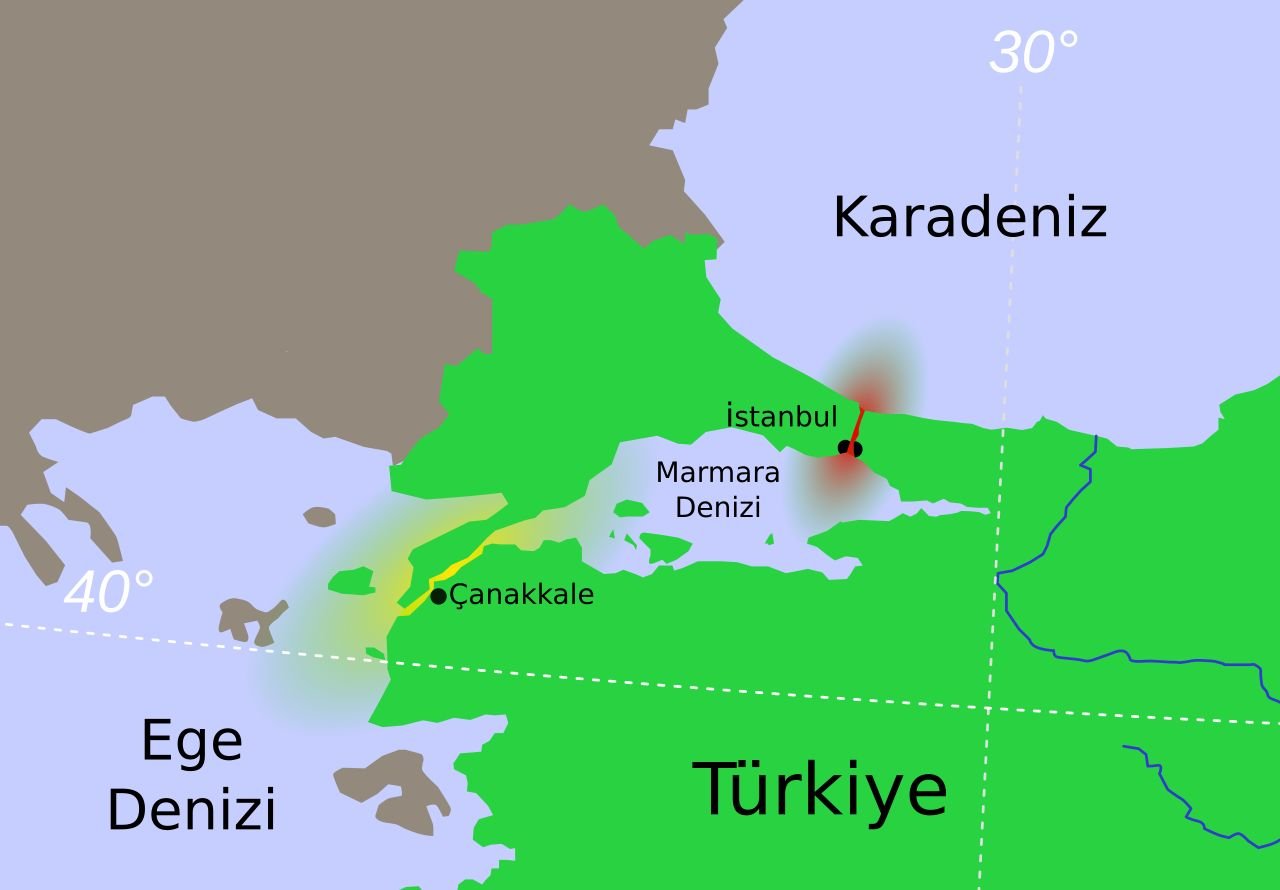
The Sea of Marmara is one of Turkey’s most unique geographical features and the only inland sea located entirely within the country. Positioned between Europe and Asia, it forms a natural connection between the Black Sea and the Aegean Sea, separating the European region of Thrace from the Asian region of Anatolia.
For thousands of years, the Sea of Marmara has been a vital maritime crossroads, influencing trade routes, military campaigns, migrations, and the development of some of history’s greatest civilizations. Today, it remains an important transportation route as well as a popular destination for tourism, sailing, fishing, and coastal exploration.
Geography and Location of the Sea of Marmara
The Sea of Marmara is connected:
- To the Black Sea through the Bosporus Strait
- To the Aegean Sea through the Dardanelles Strait
Together, the Bosporus, Sea of Marmara, and Dardanelles form the Turkish Straits system, one of the world’s most strategically important waterways.
The Bosporus divides Istanbul, Turkey’s largest city, into two continents:
- The European side (Thrace)
- The Asian side (Anatolia)
This unique position makes Istanbul one of the few cities in the world located on two continents.
Size and Physical Characteristics
The Sea of Marmara covers approximately:
- Area: 11,350 square kilometres
- Length: About 280 kilometres from east to west
- Maximum width: Around 80 kilometres
- Maximum depth: Approximately 1,370 metres
Although much smaller than Turkey’s surrounding seas, the Marmara Sea has exceptional geographic importance because it controls maritime access between the Black Sea and the Mediterranean region.
Water Characteristics and Marine Environment
The Sea of Marmara has a unique two-layer water system.
The surface waters have an average salinity of around 22 parts per thousand, making them:
- More saline than the Black Sea
- Less saline than the Mediterranean Sea
At deeper levels, salinity rises to approximately 38 parts per thousand, similar to Mediterranean waters.
Because the deep water is denser, it remains below the surface and mixes only slowly with upper layers. This creates a special marine ecosystem with different conditions at various depths.
Rivers Flowing into the Sea of Marmara
Several rivers contribute freshwater to the Marmara basin.
Important rivers include:
- Biga River
- Gönen River
- Susurluk River
- Kocabaş River (ancient Granicus)
Most of these rivers originate in Anatolia. Since the Thrace region has fewer large rivers flowing southward, the freshwater contribution mainly comes from the Asian side.
The rivers have historically supported fertile agricultural areas around Bursa, Balıkesir, and Çanakkale.
The Islands of the Sea of Marmara
The Sea of Marmara contains two important island groups that have played significant roles throughout history.
The Princes’ Islands (Adalar)
Located close to Istanbul, the Princes’ Islands are among Turkey’s most popular island destinations.
The group consists of several islands, including:
- Büyükada
- Heybeliada
- Burgazada
- Kınalıada
The islands are famous for:
- Historic wooden mansions
- Pine forests
- Peaceful atmosphere
- Horse-drawn carriages (historically)
- Cycling routes
- Sea views of Istanbul
They provide a relaxing escape from the busy urban environment of Istanbul.
The Marmara Islands
Located in the southwestern part of the sea, the Marmara Islands have been famous since antiquity for their marble quarries.
The name Marmara comes from the ancient Greek word:
mármaron (μάρμαρον) meaning “marble.”
The islands supplied high-quality marble used in important buildings throughout the Greek, Roman, Byzantine, and Ottoman periods.
Today, the islands are known for:
- Beaches
- Fishing villages
- Traditional island life
- Nature tourism
Historical Name: Propontis
In ancient times, the Sea of Marmara was known as Propontis.
The name comes from ancient Greek:
- Pro = before
- Pontos = sea
Meaning:
“The sea before the sea.”
Ancient Greek sailors travelling from the Aegean Sea toward the Black Sea passed through Propontis before reaching the northern waters.
Because of its strategic position, controlling the Sea of Marmara was essential for ancient powers including:
- Greeks
- Persians
- Romans
- Byzantines
- Ottomans
The Sea of Marmara in Greek Mythology
The Sea of Marmara appears in one of the most famous stories of Greek mythology: the voyage of the Argonauts.
According to legend, Jason and the Argonauts encountered a violent storm while crossing the Propontis and were forced back to the island of Cyzicus.
The heroes were mistaken for enemies by King Cyzicus and his warriors. A tragic battle followed during the night, resulting in the accidental death of the king.
Different versions of the myth attribute the fatal blow either to:
- Jason
- Heracles (Hercules)
The story remains one of the most memorable legends connected with the ancient Propontis.
Ancient Cities Around the Sea of Marmara
The shores of the Sea of Marmara have been home to many important settlements.
Notable ancient and historic sites include:
Cyzicus (Kyzikos)
Located near modern-day Erdek, Cyzicus was one of the most important cities of ancient Mysia.
It was famous for:
- The Temple of Hadrian
- Large harbor facilities
- Trade connections
- Marble architecture
Byzantium
Founded on the Bosporus, Byzantium later became:
- Constantinople
- The capital of the Byzantine Empire
- Istanbul
Nicomedia
Modern İzmit was the capital of the Roman province of Bithynia and later became one of the most important cities of the Eastern Roman Empire.
Earthquakes and the North Anatolian Fault
The Sea of Marmara lies above the North Anatolian Fault, one of the most active earthquake zones in the world.
This fault system has produced many powerful earthquakes throughout history.
One of the most significant recent events was:
The 1999 İzmit Earthquake
which caused extensive damage in the Marmara region.
Because of this geological activity, earthquake research and preparedness remain important issues for cities around the sea, especially Istanbul.
Tourism Around the Sea of Marmara
The Sea of Marmara offers visitors a combination of:
- History
- Islands
- Beaches
- Nature
- Sailing
- Local cuisine
- Cultural experiences
Popular destinations include:
Istanbul Coastline
The Marmara coastline of Istanbul offers:
- Bosporus and Marmara cruises
- Historic neighborhoods
- Seafood restaurants
- Waterfront promenades
Bursa and Mudanya
Located on the southern coast, Bursa and Mudanya offer:
- Ottoman heritage
- Thermal springs
- Coastal villages
- Traditional seafood restaurants
Yalova
Known for:
- Thermal springs
- Green landscapes
- Forests
- Weekend tourism from Istanbul
Balıkesir and Erdek
The northern shores provide:
- Beaches
- Island excursions
- Fishing villages
- Nature tourism
Sailing and Maritime Activities
The Sea of Marmara is popular for:
- Yacht cruises
- Sailing trips
- Fishing tours
- Island excursions
- Coastal exploration
Its protected waters make it suitable for both experienced sailors and leisure travelers.
Environmental Challenges
Despite its importance, the Sea of Marmara faces environmental pressures, including:
- Urban pollution
- Industrial waste
- Overfishing
- Marine ecosystem changes
The protection of this unique inland sea has become an important environmental priority for Turkey.
Discovering the Sea of Marmara
The Sea of Marmara is much more than a body of water between two continents. It is a place where geography, mythology, history, and modern life meet.
From the ancient Propontis of Greek sailors to the maritime heart of the Byzantine and Ottoman empires, this inland sea has shaped the destiny of civilizations for more than two thousand years.
Today, visitors can explore historic islands, ancient ports, coastal towns, and vibrant Istanbul shores while experiencing one of the world’s most fascinating maritime regions – a sea that truly connects Europe and Asia.
Leave a Reply
You must be logged in to post a comment.