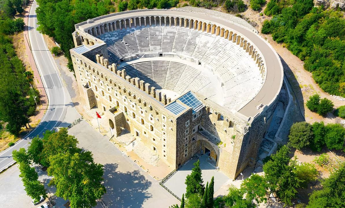
GTurkiye

Category: Archaeology

  • The Aspendos Ancient Theatre one of the best-preserved Roman-era theatres in the world

    The Aspendos Ancient Theatre one of the best-preserved Roman-era theatres in the world

    Turning off the AntalyaAlanya road at kilometer 30 in the direction of the village of Belkis we come to the best-preserved ancient theater in Turkey. According to Strabo, the city of Aspendos was founded by colonists who came from Argos under the leadership of Mopsos. Coins minted in the 4th and 5th centuries B.C. give the city’s name as Estwediya. (Aspendos had the distinction of being the only city besides Side that coined money in its own name at that early period.)

    For a while, the city was a member of the Athenian maritime alliance (the Delian League). A naval battle was fought off Aspendos in 469 B.C. during which the Persian fleet was defeated by the forces of the Athenian general Cimon. Despite this however we see Aspendos being used as a Persian base in 411 B.C. With Alexander’s defeat of the Persians in 334 B.C., Aspendos was freed of Persian rule. It was ruled by various Hellenistic period kings following the death of Alexander and like most other cities in Asia Minor it came under Roman rule in 133 B.C.

    The city particularly flourished in the 2nd and 3rd centuries A.D. In the 5th century the city’s name was changed to Primupolis. Aspendos was badly affected by the Arab incursions in the 8th century. The Seljuks, who arrived in the area in the 12th century, appear to have made use of some of the ancient structures, the theater being among them. One may approach the ruins by car as far as the theater and we shall begin our tour there.

    The Aspendos theater is built of regularly dressed blocks of conglomerate while the door and window frames are of a cream-coloured limestone. One enters the skene through five doors, the one in the middle on the east being larger than the other four on located two on either side. The stage building is a two-tiered facade with four rows of windows, each row of which is of a different form and size. The niches contained decorative statuary. Even today the facade has an attractive appeal.

    From inscriptions at the theater we know that the structure was built during the reign of Marcus Aurelius (161-180) by two brothers, Curtius Crispinus and Curtius Auspicatus, to be dedicated to the gods and the emperors. The architect’s name was Zeno. The auditorium is divided in two by a diazoma and there is a gallery of columns surmounting the top row of seats. While the theater appears to be built on barrel vaulted substructures, parts of it do rest against the hillside. With a seating capacity of 20,000 the Aspendos theater is still useable today.

    North of the theater at the same level is the stadium. The Aspendos stadium resembles the one at Perge: the spectator’s seats are also set on vaults. To the south of the theater are the remains of a gymnasium and baths now in ruins.If we ascend to the acropolis on the hill above the theater from the path connecting the theater and stadium we pass through the eastern of the city’s three gates into the ruins of the city proper.

    Proceeding west from this gate, we come upon a basilica, part of which was used for government and civic affairs and as a courthouse. Much of this section is still standing. The triple-nave basilica extending 105 meters to the west was a commercial building while the agora lay to its west. The agora was surrounded by public buildings. West of the agora is a covered marketplace measuring 70 meters in length.

    The front was open consisting of a row of shops with a stoa in front. North of the agora are the remains of a nymphaion (fountain) of which only the facade measuring 32.50 meters in length and 15 meters in height remains. This elaborately decorated facade has two rows of niches. Northwest of the fountain are the remains of the bouleuterion, which was used as the city state’s parliament hall.

    In the center of the ruin are the traces of the foundations of a monumental arch. At the southern end of the basilica are the remains of exedrae, which served both as pedestals for statues and stone benches for the public. Another of the remains worth mentioning at Aspendos are the city’s magnificent aqueducts, parts of which are in the nearby village and on the site of the ruins.

  • Priene is one of the best-preserved examples from Antiquity to the present day

    The ancient city of Priene, located in the south of Ephesus, offers the magnificent features of a city dating back to the 4th century. The ancient city of Priene is located 15 kilometers southwest of the Söke district of Aydın, on the southern slopes of Samsun Mountain (Mykale). The first information about this city, which was included in the Ionian League, is found in ancient sources in the 7th century BC. The city was rebuilt in the middle of the 4th century BC on the basis of the plan named after Hippodamos of Miletus. Priene was an episcopal center during the Byzantine period. The city, which is gradually moving away from the sea due to the alluvium carried by the Menderes River, has lost its value over time. It is known that Priene was completely evacuated in the 13th century.

    The fact that the city was built on a steep cliff offered an advantage in terms of defense. Priene is one of the best preserved examples of urban planning from Antiquity to the present day. In this respect, it is extremely important to comprehend the development of urban planning in Anatolia and to set an example for contemporary planning practices. Priene was designed by the famous city planner Hippodamos of Miletus and designed the city on a chessboard plan, with the streets of the Bosphorus intersecting each other at right angles. The main streets run in the east-west direction, and the secondary streets run in the north-south direction. As a whole city, it faces south. This arrangement allowed the Priene houses to receive sunlight in the winter months and the mouths to the roofs of the houses in the summer.

    The plan of Hippodamos divided the city into insulas or islands. Each rectangle measures the area… He had either four houses or an official building. Some structures, such as the stadium and the theater, did not fit into the city plan due to their shape and/or size. In addition to urban planning, there are three monuments that visit Priene: The Priene theater is one of the best examples of Greek-type theaters. This horseshoe-shaped theater is built on the hillside and has a seating capacity of 5000 people. The theater has undergone renovations in different periods of history.

    The Temple of Athena, located about 100 meters above sea level and the Menderes Valley, attracts the attention of visitors. Designed by architect Pytheos, who was also the architect of the Mausoleum in Halicarnassus, this Ionic temple became one of the most famous monuments in Ionia. After his temple in Priene, Pyteos published a book explaining the principles of Ionian architecture. The attributes for which he used this temple became the canonical orders of Ionic architecture.

    In the center of the ancient city, there are many monumental buildings built by well-known architects of the period and skillfully integrated into the city plan. Among the prominent buildings of the city are the Temple of Demeter, the Temple of Athena, the agora, the Temple of Zeus, the bouleuterion, the upper gymnasion, the lower gymnasion, the Temple of the Egyptian Gods, the residence of Alexander the Great, the Byzantine church, and the necropolis area. The theater, another important structure of the city, was built in 350 BC and has a capacity of 5 thousand people. In addition to these, the houses of Priene, one of the best-preserved examples of its kind from the Late Classic and Hellenistic periods, provide valuable information about the settlement history. In this respect, the city is described as the “Pompeii of Anatolia”.

    Buleterion
    The third interesting building in Priene is its charming town hall with seating capacity of 640 people. Town hall where the members of the city council used to meet on the special days of the week was covered over with a wooden roof. The Buleterion is entered through two major doors.

  • Gobeklitepe has been understood to be a unique sanctuary for the Neolithic period

    Gobeklitepe Archaeological Site is located near Orencik Village, 18 kilometers northeast of Sanlıurfa city center. The site was discovered in 1963 during a survey conducted jointly by the Universities of Istanbul and Chicago and identified as “V52 Neolithic Settlement”. The real value of the site began to emerge with the excavations started after 1994. These excavations revealed that Gobeklitepe was a cult center dating back 12000 years.

    In the middle of about 20 round and oval structures with a diameter of 30 meters, there are 2 “T” shaped, 5 meter high, freestanding limestone columns. There are also smaller columns on the inner walls of the structures. The aforementioned scientific data on Gobeklitepe provides important information that requires a re-evaluation of the theoretical framework and dating of the Neolithic period in archaeological studies. Gobeklitepe, with its location, dimensions, dating and the monumentality of its structures, has been understood to be a unique sanctuary for the Neolithic period. Since the site remained untouched in its natural environment for 12000 years, it yielded important archaeological finds.

    Gobeklitepe, a work of great organization and imagination, is the oldest monument of this size and beyond the firsts, it constitutes the zero point of history in many ways. The construction of temples requiring advanced architecture at a time when man was living as a hunter-gatherer has caused astonishment all over the world. Reflecting the belief world of prehistoric man, the temples enriched with animist figures have made Gobeklitepe one of the most important discoveries in the history of archaeology.

    Undoubtedly, in addition to its fascination, all kinds of data and scientific results obtained from the excavations regarding prehistoric life are of great importance for the history of humanity. Gobeklitepe, the first temple built during the time of hunter and gatherer human societies, which were far away from the concepts of settlement and agriculture, before the transition to urban life, is considered to be the “greatest archaeological discovery” of recent years. The temple, which is still unanswered how it was designed about 12 thousand years ago, attracts attention with the fact that it was built about 7,500 years before the Pyramids in Egypt and Stonehenge in England.

  • The Ancient City of Myra one of the most interesting Lycian tombs in Turkey

    myra demre kale

    Myra, a few kilometers away from Demre, is a city built into the rocks overlooking the sea. Perhaps one of the most beautiful examples of its kind in Anatolia… It is understood from the ruins, tombs and Lycian inscriptions spread over a wide area that it was an old city dating back to the 5th century BC.

    It is known that in the 17th century AD, Emperor Germanicus visited Myra with his wife Agrippina. Here: By climbing the stairs, it is possible to reach the structures carved into the rocks. It depends on your strength to climb the stairs… St. Paul: In 60 AD, he visited Myra. In the 2nd century AD, Myra was honored with the title of Metropolis and witnessed a great development. Under Byzantine rule, the city again became a religious and administrative center, especially in the 4th and 5th centuries.

    The remains of Lycia’s largest theater of its time can be seen today. It is important because it is the best preserved theater that has survived to the present day. With 29 seating rows and a capacity of 9-10 thousand spectators, the theater leans against the hill. Even today, it is occasionally used for some festivals.

  • Consider the evidence you will see on Noah’s Ark

    This is Noah’s Ark!!!
    Friends, please prayerfully consider the evidence you will see on Noah’s Ark. It may not be important or necessary for you to learn of this discovery, but there are millions of people who need confirmation of biblical artifacts in order to strengthen their faith in God. Satan is strongly attacking this and other discoveries in order to deceive men of God’s truth. All the false stories about finding Noah’s ark were invented by Satan to “muddy the water,” and cause disbelief in the genuine.

    The Bible
    There is only one verse in the Bible which gives us a hint of where we the ark came to rest, “the ark rested…upon the mountains of Ararat.” Genesis 8:4. Where is Ararat? The name Ararat is a large area or ancient country covering eastern Turkey, western Iran and western Russia. “The name Ararat, as it appears in the Bible, is the Hebrew equivalent of… Uratu, ancient country of southwest Asia… mentioned in Assyrian sources from the early 13th century BC” Encyclopaedia Britanica 15th ed. Some have mistakenly assumed the Bible meant the ark came to rest on Mount Ararat (Agri Dagh), but that is not the case. Mount Ararat is 17,000 feet tall, and is a post-Flood volcanic mountain that gained its extra height after the Flood, therefore there is no reason to assume it is a more likely candidate for the resting place of the ark. The ark came to rest in the mountains of the ancient country of Uratu, not Mt. Ararat.

    The Historical Record
    Flavius Josephus, c. 90 AD, the famous Jewish historian stated, “Its remains are shown there by the inhabitants to this day.” He quotes Berosus the Chaldean, c. 290 BC, who indicated tourists would take home pieces of the ark for making good-luck charms, “It is said there is still some part of this ship in Armenia, at the mountain of the Cordyaeans; and that some people carry off pieces of the bitumen, which they take away, and use chiefly as amulets for the averting of mischiefs.” These comments tend to indicate its location would not be in an inaccessible area. At some point, the ark was covered by a mud and lava flow which caused future generations to lose its location.

    Life Magazine 1960
    The 1960 expedition to the ark found a formation whose top sides were even with ground level as seen in the photos above. The site researched by Ron Wyatt is 18.2 miles south of Mount Ararat at the elevation of 6,524 ft., in the “mountains of Ararat.” A Turkish captain, Llhan Durupinar, was reviewing NATO Geodetic Survey photographs of the area in 1959, and noticed a boat shaped formation. Others in the U.S. then analyzed the photograph including Dr. Arthur J. Brandenburger, world famous expert in photogrammetry, who said “I have no doubt at all that this object is a ship. In my entire career I have never seen an object like this on a stereo photo. Even the approximate length of the object fits” The Ark File, p118. An expedition sponsored by a party from the U.S. included among others, Rene Noorbergen, later author of The Ark File; and George Vandeman, evangelist, and Dr. Brandenburger.

    They made a visual inspection of the site and conducted no scientific studies, only some digging and dynamiting of the ark and and mistakenly believed this site was just an “odd geological formation.” The expedition was expecting to find on the surface of the ark “petrified beams” The Ark File, p126, by digging in a few places. An article then appeared in the September 5th, 1960, Life magazine, shown at left, revealing a very impressive aerial photo of an extremely large boat-shaped object, plus two photos taken by the expedition. Seventeen years later in 1977, Mr. Wyatt made his first of 24 trips to the ark, and he was impressed that this really was the remains of Noah’s Ark! In the research he performed over the next 15 years, Mr. Wyatt successfully performed metal detection tests and subsurface radar scans of the site, and he proved this site really IS the mud-and-lava covered remains of Noah’s Ark! (Another early book on searching for the ark has some old photos you may like to view. The book is The Lost Ship of Noah, by Charles Berlitz, 1987.)

    Government Confirmation
    The Turkish government has double-verified Mr. Wyatt’s tests, and they have given him credit for the visitor discovery. The announcement appeared in Turkey’s largest newspaper on June 21, 1987. The area was first designated a National Park, and then it was upgraded to the status of a National Treasure. The government has built a visitors’ center overlooking the site and issued official tourist brochures so people of all races can come and see the ark!