Category: Archaeology

  • Ancient City of Teimiussa: The Sunken Lycian Harbor of Üçağız, Antalya

    Nestled along the tranquil shores of Üçağız Bay on Turkey’s Mediterranean coast, the Ancient City of Teimiussa (also spelled Teimioussa or Teimiussa) is one of Lycia’s most charming yet least-visited archaeological sites. Located just east of the modern village of Üçağız in Antalya Province, this peaceful ancient harbor offers a rare combination of untouched history, crystal-clear waters, and breathtaking natural scenery.

    Unlike many of Turkey’s larger archaeological sites, Teimiussa remains largely unspoiled. Here, visitors can wander among Lycian sarcophagi, rock-cut tombs, and partially submerged ruins while enjoying spectacular views across one of the most beautiful sections of the Mediterranean coast.


    A Small Harbor in Ancient Lycia

    Although little is known about the political history of Teimiussa, archaeological evidence indicates that the settlement was inhabited from at least the 4th century BC, during the Lycian period.

    Unlike major regional centers such as Myra, Patara, or Xanthos, Teimiussa never developed into an independent city-state capable of minting its own coins. Historians believe it functioned as a small harbor settlement serving the larger inland cities of Myra and Cyaneae, playing an important role in regional maritime trade and transportation.

    Its sheltered natural harbor made it an ideal anchorage for merchant vessels sailing along the Lycian coast.


    An Ancient Town Embraced by Nature

    One of Teimiussa’s greatest attractions is the harmony between its archaeological remains and the surrounding landscape.

    Olive trees, Mediterranean shrubs, rocky hillsides, and the calm turquoise waters of Üçağız Bay create an atmosphere where history and nature blend seamlessly. The peaceful setting has changed little over the centuries, allowing visitors to experience the ancient harbor much as sailors once did.

    The absence of large crowds further enhances the site’s timeless charm.


    Lycian Rock-Cut Tombs

    Near the western entrance of the site stand two remarkable rock-cut tombs, carved directly into the natural limestone cliffs.

    Designed to resemble traditional Lycian wooden houses, these tombs reflect one of the region’s most distinctive architectural styles.

    Although the stone doors have long disappeared, visitors can still admire:

    • Carefully carved façades
    • Door frames imitating timber construction
    • Ancient burial chambers
    • Fine examples of Lycian funerary architecture

    One tomb is particularly notable for its relief depicting a nude child, while a well-preserved Lycian inscription above the entrance dates to approximately the 4th century BC, providing valuable evidence of the city’s early history.


    The Necropolis of Sarcophagi

    The most striking feature of Teimiussa is its extensive necropolis, where dozens of beautifully preserved Lycian sarcophagi are scattered across the hillside overlooking the sea.

    Most visible tombs belong to the Roman Imperial period, although earlier Lycian traditions remained influential in their design.

    Many sarcophagi feature inscriptions recording the names of their owners, family members, and legal protections against tomb robbery.

    Interestingly, several inscriptions identify individuals originating from the nearby cities of Cyaneae and Myra, suggesting close administrative and social ties between these communities.

    Some inscriptions even specify that anyone caught violating the tombs would be fined, with the penalties payable to the authorities of Cyaneae or Myra. These remarkable legal texts provide valuable insight into the sophisticated civic organization of ancient Lycia and the importance placed on protecting family burial places.


    The Ancient Harbor

    At the eastern end of the settlement, visitors reach the remains of Teimiussa’s ancient harbor.

    Stone steps carved directly into the bedrock descend toward a small quay where merchant ships and fishing boats once docked.

    Although modest in scale, this harbor played an important role in regional trade and communication, linking inland Lycian settlements with the wider Mediterranean world.

    Today, the tranquil waterfront remains one of the most picturesque locations on the Turkish coast.


    The Sunken Ruins

    One of Teimiussa’s most fascinating features is its partially submerged archaeological remains.

    Over many centuries, earthquakes and gradual geological subsidence caused parts of the ancient shoreline to sink beneath the sea.

    Today visitors can observe:

    • Ancient harbor walls beneath the water
    • Submerged stone foundations
    • Sections of quays
    • Masonry blocks visible through the crystal-clear sea

    These underwater remains create a magical atmosphere and have made Teimiussa one of the highlights of the famous Kekova boat tours.

    The sunken ruins should not be confused with the nearby Sunken City of Dolchiste (Kekova), although both belong to the same remarkable archaeological landscape.


    Archaeological Importance

    Although Teimiussa has never undergone large-scale excavation, the site provides valuable information about daily life in smaller Lycian coastal communities.

    Archaeological discoveries indicate:

    • Continuous occupation from the Classical through Roman periods.
    • Strong connections with neighboring Lycian cities.
    • A prosperous maritime economy.
    • Rich funerary traditions.
    • Long-term adaptation to the changing coastline caused by earthquakes.

    Its inscriptions remain an important source for understanding the administrative organization of the Lycian League.


    Visiting Ancient Teimiussa

    Teimiussa is located immediately east of the village of Üçağız, approximately:

    • 35 km from Demre
    • 50 km from Kaş
    • Around 170 km from Antalya

    The site is easily explored on foot and is often included in itineraries featuring nearby archaeological attractions.

    Many visitors also arrive by sea as part of daily boat cruises around Kekova Island.


    Nearby Attractions

    Teimiussa is ideally situated for exploring some of the Mediterranean’s most spectacular historical sites, including:

    • Kekova Island
    • Sunken City of Dolchiste
    • Simena (Kaleköy)
    • Ancient City of Myra
    • St. Nicholas Church in Demre
    • Ancient City of Aperlai
    • Ancient City of Cyaneae
    • Kaş
    • Kaputaş Beach

    Why Visit Ancient Teimiussa?

    Teimiussa is one of the hidden gems of the Lycian Coast. Although it lacks the monumental temples and theatres of larger ancient cities, it offers something equally captivating—a peaceful landscape where history, archaeology, and nature exist in perfect harmony.

    Walking among centuries-old sarcophagi, discovering Lycian inscriptions, descending to the ancient harbor, and gazing into the clear waters that conceal submerged ruins creates an unforgettable experience. Combined with nearby Kekova and Simena, Teimiussa provides one of the finest opportunities to explore the authentic spirit of ancient Lycia away from the crowds, making it an essential destination for history lovers, photographers, hikers, and anyone seeking the quieter side of Turkey’s Mediterranean heritage.
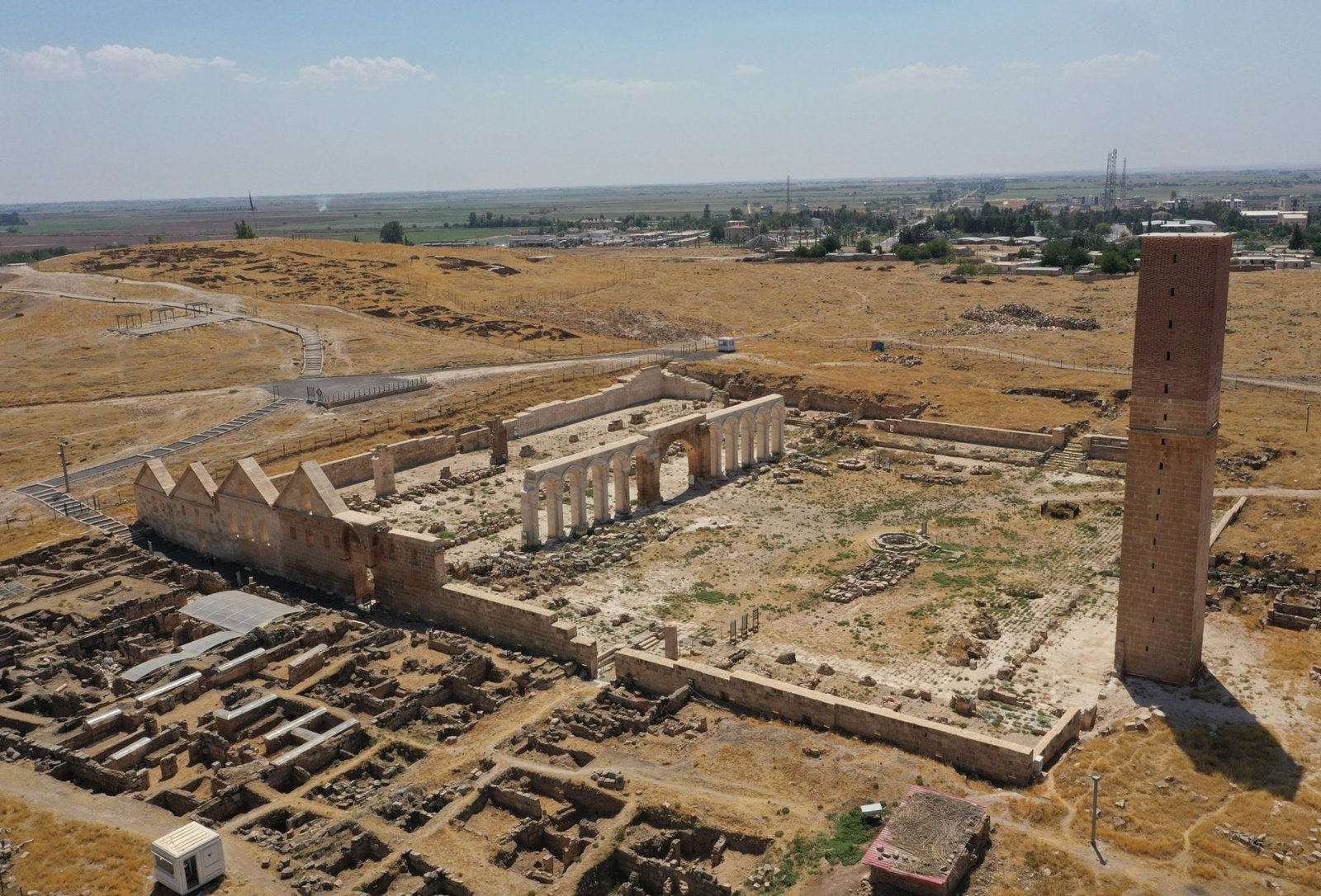
  • Ancient City of Harran: The Biblical City of Prophets, Scholars, and Beehive Houses

    Ancient City of Harran: The Biblical City of Prophets, Scholars, and Beehive Houses

    Located approximately 50 kilometers south of Şanlıurfa, near the Syrian border, the Ancient City of Harran is one of the oldest continuously inhabited settlements in the world. With a history stretching back more than 4,000 years, Harran has served as a religious center, a flourishing commercial hub, a seat of learning, and a crossroads of civilizations connecting Mesopotamia with Anatolia and the Mediterranean.

    Today, Harran is famous for its unique beehive-shaped mudbrick houses, its impressive medieval ruins, its association with the Prophet Abraham, and its importance in Assyrian, Babylonian, Roman, Islamic, and Ottoman history. The archaeological site forms part of the rich cultural landscape of southeastern Turkey and is included on UNESCO’s Tentative World Heritage List.


    A City at the Crossroads of Civilizations

    Harran (also spelled Haran) occupies a strategic position on the ancient trade routes linking Nineveh, Carchemish, and the great cities of Mesopotamia. For thousands of years, merchants, pilgrims, scholars, and armies passed through this fertile plain, making Harran one of the most important cities of the ancient Near East.

    Archaeological evidence suggests that the city existed as early as 2000 BC, although some scholars believe settlement in the area may be even older. Throughout its long history, Harran came under the control of numerous civilizations, including:

    • The Assyrians
    • Babylonians
    • Persians
    • Macedonians
    • Romans
    • Byzantines
    • Umayyads
    • Abbasids
    • Seljuks
    • Ayyubids
    • Ottomans

    Each left lasting traces that visitors can still explore today.


    Harran in the Bible

    Harran occupies a prominent place in biblical history.

    According to the Book of Genesis, Abraham (Prophet Ibrahim) and his family stopped in Harran after leaving Ur of the Chaldeans on their journey toward the Promised Land. It was here that Abraham’s father, Terah, died before Abraham continued his journey to Canaan.

    Because of this connection, Harran is considered sacred by followers of Judaism, Christianity, and Islam, making it one of the world’s oldest pilgrimage destinations.

    Local tradition preserves several sites associated with Abraham’s stay, although these traditions are not archaeologically verified.


    The Temple of the Moon God Sin

    Long before the arrival of the Abrahamic religions, Harran was one of Mesopotamia’s greatest religious centers.

    For over a thousand years, the city was famous for the magnificent Temple of Sin, dedicated to the Mesopotamian Moon God Sin (Nanna).

    The temple attracted pilgrims from across the ancient Near East and became one of the most influential religious sanctuaries of Assyria and Babylonia.

    The deity Sin was commonly represented as:

    • A crescent moon
    • A long-bearded god
    • Wearing a horned crown

    Worship of the Moon God continued in Harran until approximately the 6th century AD, long after many neighboring regions had adopted Christianity.

    Later, a medieval fortress was constructed over parts of the ancient temple complex.


    Capital of the Neo-Assyrian Empire

    Following the fall of Nineveh in 612 BC, Harran briefly became the final capital of the Neo-Assyrian Empire.

    King Ashur-uballit II attempted to continue Assyrian resistance from Harran, making the city one of the last strongholds of one of history’s greatest empires.

    Although the Assyrians ultimately fell to the combined Babylonian and Median armies, Harran retained its regional importance for centuries afterward.


    The Battle of Carrhae

    One of the most famous events in Roman history occurred near Harran in 53 BC.

    The Roman general Marcus Licinius Crassus, one of the members of Rome’s First Triumvirate alongside Julius Caesar and Pompey, led a massive army against the Parthian Empire.

    At the Battle of Carrhae, Roman legions suffered one of their greatest defeats.

    The Parthian cavalry, using highly skilled mounted archers, overwhelmed the Roman forces. Crassus was killed during the campaign, and thousands of Roman soldiers were either captured or died on the battlefield.

    The battle permanently altered the balance of power between Rome and the eastern empires.


    Emperor Caracalla’s Assassination

    Harran also witnessed another dramatic moment in Roman history.

    On 8 April AD 217, Emperor Caracalla was assassinated while traveling near Harran, reportedly after stopping during a journey to visit the sanctuary of the Moon God.

    His death marked another turning point in Roman imperial politics and added to Harran’s remarkable historical legacy.


    The Great Mosque (Ulu Cami)

    One of Harran’s most significant Islamic monuments is the Great Mosque (Ulu Cami).

    Constructed during the Umayyad period in the early 8th century, it is regarded as one of the oldest monumental mosques in Anatolia and one of the earliest centers of Islamic education.

    Although now largely in ruins, visitors can still admire:

    • The remains of the large prayer hall
    • Courtyard foundations
    • Stone arcades
    • Sections of the impressive minaret
    • Decorative stonework

    The mosque once served not only as a place of worship but also as an important center for scientific learning.

    Excavations have also uncovered inscriptions connected with the Babylonian king Nabonidus, which are now displayed in the Şanlıurfa Museum.


    Harran University: A Medieval Center of Learning

    During the Abbasid period, Harran became one of the Islamic world’s leading intellectual centers.

    The famous Harran University, founded in the 8th century, attracted scholars from across the Middle East and became renowned for its studies in:

    • Astronomy
    • Mathematics
    • Medicine
    • Philosophy
    • Theology
    • Natural sciences

    Many important Greek scientific works were translated into Arabic here, helping preserve classical knowledge that later reached medieval Europe.

    The university remained one of the region’s foremost educational institutions for centuries.


    Harran Castle

    Dominating the southern part of the archaeological site are the remains of Harran Castle.

    The present structure dates largely to the 12th and 13th centuries, although it was built upon much older foundations, possibly including parts of the ancient Temple of Sin.

    From its towers, visitors enjoy sweeping views across the vast Harran Plain.


    The Ancient City Walls

    Harran was once enclosed by impressive defensive walls reinforced with numerous towers.

    Originally featuring twelve monumental gates, only five survive today.

    Most visible sections date from the medieval Islamic period, although parts incorporate much older masonry from earlier civilizations.


    The Famous Beehive Houses

    No visit to Harran would be complete without exploring its iconic beehive-shaped houses, perhaps the city’s most recognizable symbol.

    Constructed entirely from:

    • Sun-dried mud bricks
    • Clay mortar
    • Straw
    • Local stone foundations

    these remarkable dwellings have remained virtually unchanged for centuries.

    The conical domes, typically standing 4 to 5 meters high, naturally regulate indoor temperatures by keeping interiors cool during the scorching summer months and warm in winter.

    Several restored houses now serve as museums, traditional guesthouses, and cultural centers where visitors can learn about local customs, architecture, and daily life.


    The Sabians and Ancient Astronomy

    For centuries, Harran was also associated with the mysterious Sabians, a religious community renowned for its astronomical knowledge and reverence for celestial bodies.

    Their temples, located in the surrounding region, were dedicated to the Sun, Moon, Jupiter, Venus, Saturn, and Mercury.

    The Sabian tradition survived remarkably long, reportedly continuing in parts of the Harran region until the 17th century, making it one of the longest-lasting ancient religious traditions in the Near East.


    What to See in Harran

    Highlights of a visit include:

    • Harran Castle
    • Great Mosque (Ulu Cami)
    • Ancient city walls and gates
    • Traditional beehive houses
    • Archaeological mound (Tell Harran)
    • Ancient streets
    • Remains of the Temple of Sin
    • Traditional courtyards and village houses
    • Harran Cultural House
    • Panoramic viewpoints across the Harran Plain

    Visiting Harran

    Harran is easily reached from Şanlıurfa by car or organized tour and is often combined with visits to:

    • Göbekli Tepe
    • Şanlıurfa Archaeology Museum
    • Balıklıgöl (Pool of Sacred Fish)
    • Soğmatar Ancient City
    • Bazda Caves
    • Halfeti

    The best seasons to visit are spring (April–May) and autumn (September–November), when temperatures are pleasant for exploring the archaeological site.


    Why Visit Ancient Harran?

    Ancient Harran is unlike any other destination in Turkey. Few places combine biblical history, Mesopotamian religion, Roman warfare, Islamic scholarship, and living architectural traditions in such a remarkable setting. From the legendary journey of Abraham and the worship of the Moon God Sin to the Battle of Carrhae and the medieval university that helped preserve classical science, Harran has played a pivotal role in the history of civilization.

    Today, wandering through its ancient ruins, climbing the medieval castle, and stepping inside the iconic beehive houses offers visitors an unforgettable experience. Harran is not merely an archaeological site—it is a living testament to thousands of years of human history, faith, knowledge, and cultural exchange at the crossroads of the ancient world.

  • Ancient City of Cyaneae: A Forgotten Lycian Stronghold in Muğla, Turkey

    Hidden among the rugged hills of the Teke Peninsula in southwestern Turkey, the Ancient City of Cyaneae (also spelled Kyaneai) is one of Lycia’s most atmospheric archaeological sites. Overlooking the countryside near the village of Yavu, between Kaş and Demre, Cyaneae was once a prosperous member of the Lycian League, flourishing under both Hellenistic and Roman rule.

    Although overshadowed by better-known Lycian cities such as Xanthos, Patara, Myra, and Olympos, Cyaneae rewards visitors with remarkably preserved ruins, impressive funerary monuments, and panoramic views that evoke the grandeur of ancient Lycia.


    The Meaning of Cyaneae

    The name Cyaneae derives from the ancient Greek word kyaneos, meaning “dark blue” or “deep blue.” The exact reason for this name remains unknown. It may have referred to the color of nearby rock formations, the surrounding landscape, or perhaps the distant Mediterranean Sea visible from the elevated settlement.

    Despite its frequent mention by ancient geographers, surprisingly little was written about the city itself. Much of what historians know today comes from archaeological discoveries and inscriptions found on-site.


    A Prosperous City of the Lycian League

    Cyaneae occupied a strategically important position in central Lycia and became one of the region’s principal urban centers. During the Roman Imperial period, it belonged to the Lycian League, one of history’s earliest known federations of self-governing cities.

    One important inscription records the generosity of a wealthy citizen named Jason, who lived during the reign of the Roman Emperor Antoninus Pius (AD 138–161). Jason donated substantial sums of money to neighboring cities and was honored with the prestigious title of Lyciarch, the elected president of the Lycian League. His story reflects both the prosperity of Cyaneae and the strong civic traditions that characterized Lycian society.


    A Naturally Fortified Hilltop City

    Cyaneae was built atop a steep limestone hill overlooking the surrounding valleys, giving it excellent natural defenses.

    The city was enclosed by fortification walls on its northern, western, and eastern sides, while the steep southern cliffs provided sufficient protection without additional walls. Most of the visible fortifications date from the Late Roman and Byzantine periods, when older building stones were reused to strengthen the city’s defenses.

    Three ancient gates provided access through the northern and western walls, leading visitors into what was once a thriving urban center.


    The Acropolis

    At the highest point of the city lies the Acropolis, partially hidden today among pine trees and Mediterranean vegetation.

    Although many buildings have collapsed over the centuries, the remaining foundations reveal the layout of an important administrative and residential district. Walking through the ruins offers visitors an authentic sense of discovery, with ancient walls emerging unexpectedly from the forest.


    Roman Bath Complex

    On the southwestern side of the hill stand the remains of a Roman bath complex.

    Although archaeologists have not yet fully identified the function of every room, the surviving walls indicate that the baths once formed an important social center where residents gathered to bathe, exercise, and conduct business—an essential feature of Roman urban life.


    The Famous Lycian Sarcophagi

    Cyaneae is particularly renowned for its extraordinary collection of Lycian sarcophagi, among the finest preserved in the region.

    One of the most remarkable examples is a magnificent 4th-century BC sarcophagus, still partially buried in its original position. It features a beautifully carved lid and inscriptions written in the ancient Lycian language, offering valuable evidence of the region’s unique culture before Roman rule.

    Throughout the site, visitors encounter dozens of stone sarcophagi standing exactly where they were placed over two thousand years ago, creating one of the most evocative archaeological landscapes in Turkey.


    The Roman Theatre

    The best-preserved monument at Cyaneae is its impressive Roman theatre, constructed during the 2nd century AD.

    Built into the natural hillside, the theatre includes:

    • Eleven surviving rows of seating.
    • A cavea supported by polygonal masonry.
    • Spectacular views across the surrounding valleys.
    • Evidence suggesting that wooden poles once supported large awnings (velaria) to protect spectators from the Mediterranean sun.

    Although the stage building has largely disappeared, the theatre still vividly illustrates the importance of public entertainment in Roman Lycia.


    The Necropolis

    Stretching between the theatre and the Acropolis is one of Cyaneae’s most fascinating areas—the vast necropolis.

    Hundreds of stone sarcophagi, funerary monuments, and burial chambers are scattered across the hillside, creating an extraordinary open-air cemetery unlike almost any other in Lycia.

    Many of these tombs date from the Roman period, while others preserve distinctive Lycian architectural traditions. The peaceful atmosphere allows visitors to wander among the ancient monuments much as travelers did centuries ago.


    Rock-Cut Tombs

    High on the inaccessible southern cliffs are several rock-cut tombs, carved directly into the limestone.

    Among the most remarkable is a tomb designed to resemble a small Ionic temple.

    An ancient Greek inscription records that the sarcophagus belonged to Perpenesis and his wife, while the remaining burial chambers were reserved for members of their extended family.

    The inscription also reveals that the tomb could not be opened without the approval of an organization known as the mindis, apparently an official body responsible for protecting tombs from robbery and desecration. This rare reference provides fascinating insight into ancient Lycian laws governing burial and heritage preservation.

    The tomb is generally dated to the 3rd century BC.


    Visiting Ancient Cyaneae

    Today, Cyaneae remains largely untouched by mass tourism, making it an ideal destination for travelers seeking an authentic archaeological experience.

    Visitors should expect:

    • Uneven rocky paths
    • Moderate uphill walking
    • Dense Mediterranean vegetation
    • Outstanding panoramic views
    • A peaceful atmosphere with very few crowds

    Comfortable walking shoes, water, and sun protection are strongly recommended, particularly during the summer months.


    Nearby Attractions

    Cyaneae can easily be combined with visits to several of Lycia’s most famous archaeological and natural attractions, including:

    • Ancient City of Phellos
    • Ancient City of Apollonia
    • Kekova Island
    • Simena (Kaleköy)
    • Myra Ancient City
    • St. Nicholas Church in Demre
    • Kaş
    • Kaputaş Beach
    • Patara Ancient City

    Why Visit Ancient Cyaneae?

    Ancient Cyaneae is one of southwestern Turkey’s hidden archaeological treasures. Surrounded by forests and mountains, its remarkably preserved theatre, extensive necropolis, Lycian sarcophagi, and dramatic hilltop setting offer a unique glimpse into the civilization of ancient Lycia.

    Unlike many larger archaeological sites, Cyaneae retains an atmosphere of solitude and mystery. Here, visitors can wander through centuries-old ruins almost alone, discovering temples, tombs, theatres, and city walls that have remained largely unchanged since antiquity. For history enthusiasts, photographers, and lovers of off-the-beaten-path destinations, Cyaneae is an unforgettable journey into one of Anatolia’s most fascinating ancient civilizations.

  • Ancient City of Tripolis, Denizli, Turkey

    The Ancient City of Tripolis is one of the important archaeological sites of the Lydia region, located near Yenicekent Town of Buldan District, approximately 40 kilometers north of Denizli city center in southwestern Turkey. Built on the slopes overlooking the fertile Büyük Menderes (Maeander) River Valley, Tripolis occupied a strategic position connecting the ancient regions of Lydia, Caria, and Phrygia.

    Thanks to its location at the crossroads between western Anatolia, inner Anatolia, and the Mediterranean coast, Tripolis developed as an important border city, agricultural center, and commercial settlement.

    The city reached its greatest prosperity during the Roman Imperial Period, especially in the 1st–3rd centuries AD, when impressive public buildings were constructed, including a theatre, baths, city walls, fortifications, and monumental structures.

    Today, Tripolis offers visitors a peaceful archaeological experience surrounded by vineyards, agricultural lands, and the natural beauty of the Büyük Menderes Valley.


    History

    Early Origins

    Tripolis is believed to have been founded during the Lydian Period, although archaeological evidence from the earliest phases remains limited.

    The city’s name suggests its role as a meeting point between different regions and cultures.

    Ancient sources provide little information about the city during:

    • Lydian period
    • Persian period
    • Hellenistic period

    No major architectural remains from these early periods have yet been identified.


    Roman Period: The Golden Age of Tripolis

    Tripolis flourished under Roman rule and became one of the wealthy cities of western Anatolia.

    Most of the visible ruins belong to the:

    • 1st century AD
    • 2nd century AD
    • 3rd century AD

    During this period, the city developed:

    • Monumental public buildings
    • Urban infrastructure
    • Defensive systems
    • Commercial facilities

    According to the Roman writer Pliny the Elder, another name of Tripolis was Apollonia.


    Byzantine Period

    Tripolis continued to exist during the Byzantine period and became an important religious center.

    The city appears in historical records as a bishopric center, indicating its importance within the Christian administrative system.

    During the Late Roman and Byzantine periods, stronger defensive structures were built because of increasing military threats.

    These included:

    • City walls
    • Towers
    • Fortifications

    Earthquakes and Decline

    Like many cities in the Büyük Menderes Valley, Tripolis was affected by numerous earthquakes throughout history.

    The region was also influenced by:

    • Wars
    • Political changes
    • Economic shifts

    Although the city survived for centuries, it gradually declined as regional trade routes changed.


    Geography

    Tripolis is located:

    • Approximately 40 km north of Denizli
    • Near Yenicekent in Buldan District
    • Between the Büyük Menderes River and surrounding hills

    Its location was strategically valuable because the Büyük Menderes Valley created natural connections toward:

    • The Aegean coast
    • Central Anatolia
    • The Mediterranean region

    The surrounding landscape includes:

    • Fertile agricultural plains
    • Vineyards
    • Olive groves
    • Mountain slopes

    Importance of Tripolis

    Tripolis was important for three main reasons:

    Trade

    The city controlled routes between major ancient regions:

    • Lydia
    • Caria
    • Phrygia

    Agriculture

    The fertile Büyük Menderes Valley supported:

    • Grain production
    • Vine cultivation
    • Olive farming

    Border Position

    Tripolis functioned as a transition point between cultural regions, contributing to its economic prosperity.


    Top Attractions

    Ancient Theatre

    The theatre is located in the center of the city and was constructed according to a Greek theatre plan with Roman architectural features.

    Although much of the structure has been damaged, its original scale demonstrates the importance of public entertainment.

    The theatre could accommodate approximately:

    10,000 spectators

    It was used for:

    • Performances
    • Festivals
    • Public gatherings

    Roman Bath Complex

    Located approximately 200 meters west of the theatre, the bath complex is one of the important public buildings of Tripolis.

    Although parts of the structure have collapsed, visitors can still identify:

    • Thick exterior walls
    • Vaulted spaces
    • Arched architectural elements
    • Large wall niches

    The bath reflects Roman urban culture, where public bathing was an important part of social life.


    City Building

    A large structure located approximately 150 meters south of the bath survives mainly at foundation level.

    Although its original function remains uncertain, it was likely connected with the city’s administrative or public activities.


    City Walls and Fortress

    The defensive system of Tripolis was expanded during the Late Roman and Byzantine periods.

    The city walls included:

    • Thick stone defenses
    • Towers
    • Watchtowers
    • Strategic observation points

    The wall near the theatre continues toward the highest hill, where a large defensive tower was built.

    This tower served two purposes:

    • Protecting the city
    • Monitoring approaching enemies

    Necropolis

    The necropolis of Tripolis is located on the eastern and southern slopes of the hill.

    The cemetery contains different types of ancient burials, including:

    • Rock-cut tombs
    • Podium tombs
    • Sarcophagi

    These burial structures provide important information about:

    • Social status
    • Religious beliefs
    • Funeral traditions

    Coins and Religious Life

    Coins discovered from Tripolis provide valuable information about the city’s identity.

    They include references to:

    • Goddess Leto
    • The Letoia Phthia games
    • The Büyük Menderes River

    These symbols reveal the religious traditions and regional connections of ancient Tripolis.


    Things to Do

    Visitors can enjoy:

    • Exploring Roman and Byzantine ruins
    • Walking through ancient streets
    • Photographing archaeological landscapes
    • Discovering the theatre and fortifications
    • Combining history with countryside tourism
    • Visiting nearby thermal and cultural attractions

    Nearby Attractions

    Laodicea Ancient City

    Located approximately 30 km south of Tripolis, Laodicea was one of the most important cities of Roman Asia Minor.

    Highlights include:

    • Stadium
    • Theatre
    • Ancient streets
    • Churches
    • Colonnaded avenues

    Hierapolis Ancient City and Pamukkale

    Approximately 20 km away, this UNESCO World Heritage Site offers:

    • Roman ruins
    • Thermal springs
    • White travertine terraces
    • Ancient theatre

    Denizli

    The regional center provides:

    • Museums
    • Shopping
    • Restaurants
    • Accommodation facilities

    Buldan

    A traditional town famous for:

    • Textile production
    • Handwoven fabrics
    • Ottoman-era houses
    • Local culture

    Food and Drink

    The Denizli region offers traditional Aegean cuisine.

    Local specialties include:

    • Denizli kebab
    • Aegean olive oil dishes
    • Fresh vegetables
    • Local herbs
    • Village bread
    • Yogurt-based dishes
    • Regional sweets

    The surrounding countryside is also known for vineyards and agricultural products.


    Accommodation

    Visitors can stay in:

    Denizli City

    Offers:

    • Hotels
    • Boutique accommodations
    • Thermal hotels

    Pamukkale

    Provides:

    • Thermal resorts
    • Tourist hotels

    Buldan

    Offers:

    • Small guesthouses
    • Traditional stays

    Climate

    Tripolis has a Mediterranean climate with inland characteristics.

    Spring (April–June)

    The best period for visiting, with mild weather and green landscapes.

    Summer (July–August)

    Hot and dry; early morning visits are recommended.

    Autumn (September–October)

    Excellent conditions for archaeology and photography.

    Winter (November–March)

    Cooler with occasional rainfall.


    Getting There

    By Car

    Approximate distances:

    • Denizli: 40 km
    • Pamukkale: 50 km
    • Laodicea: 30 km
    • Buldan: 20 km

    By Air

    Nearest airport:

    • Denizli Çardak Airport – approximately 70 km

    A rental car is recommended because public transportation to the archaeological site is limited.


    Best Time to Visit

    The best months are:

    • April
    • May
    • June
    • September
    • October

    Spring and autumn provide comfortable temperatures for walking through the ruins.


    Travel Tips

    • Wear comfortable shoes because the site includes uneven terrain.
    • Bring water during summer visits.
    • Combine Tripolis with Laodicea and Hierapolis for a complete ancient city route.
    • Visit in the morning or late afternoon for the best photography.
    • A local guide can help explain the historical importance of the ruins.

    Why Visit Tripolis?

    The Ancient City of Tripolis is a fascinating destination that reveals the rich history of western Anatolia beyond the better-known archaeological sites. Its strategic location, Roman monuments, Byzantine defenses, and connection to ancient trade routes make it an important stop for history enthusiasts.

    Surrounded by the peaceful landscapes of the Büyük Menderes Valley, Tripolis offers visitors the opportunity to explore a lesser-known but remarkable ancient city where the civilizations of Lydia, Caria, Phrygia, Rome, and Byzantium came together.

  • Ancient City of Arycanda, Antalya, Turkey

    The Ancient City of Arycanda is one of the most beautifully preserved and atmospheric archaeological sites of ancient Lycia, located in Antalya Province, near the modern village of Arif in the district of Finike. Built dramatically on the terraces of a steep mountain slope overlooking the Arycandus Valley, the city offers visitors a spectacular combination of ancient architecture and breathtaking natural scenery.

    Unlike many Lycian cities known mainly for their monumental tombs, Arycanda stands out because of its remarkably preserved urban planning, with streets, public buildings, theatres, baths, and civic spaces arranged across a series of natural terraces.

    Recent archaeological excavations and restoration projects have revealed a sophisticated ancient city that resembles an architectural model of a planned mountain settlement.

    The city is especially famous for its:

    • Well-preserved theatre
    • Odeon with marble decoration
    • Agora
    • Stadium
    • Bouleuterion
    • Roman baths
    • Necropolis
    • Terraced urban design

    For travelers exploring the ancient heritage of Antalya and the Lycian coast, Arycanda is one of the region’s most rewarding hidden gems.


    History

    Lycian Origins

    Arycanda was one of the ancient cities of Lycia, a region famous for its unique culture, language, political organization, and monumental tomb architecture.

    The name Arycanda contains the Lycian linguistic element “-nda,” which suggests that the settlement has very ancient origins, possibly dating back to the 3rd millennium BC or at least the early Lycian period.

    The earliest written references to Arycanda appear before the 5th century BC, confirming that it was already an established settlement during Classical antiquity.


    The Lycian League

    Arycanda became an important member of the Lycian League, one of the ancient world’s earliest examples of a federal political system.

    The Lycian League consisted of major Lycian cities that shared:

    • Political institutions
    • Common decisions
    • Religious traditions
    • Military cooperation

    According to evidence from Lycian League coins, Arycanda participated actively in the political and economic life of the region.


    Hellenistic Period

    After the conquests of Alexander the Great, Lycia became part of the Hellenistic world.

    Greek influences became stronger in:

    • Architecture
    • Language
    • Theatre traditions
    • Civic organization

    The city continued to develop while maintaining its local Lycian identity.


    Roman Period: The Golden Age of Arycanda

    Arycanda experienced its greatest prosperity during the Roman Imperial period, especially between the 1st and 3rd centuries AD.

    During this period, the city received magnificent public buildings, including:

    • Theatre
    • Odeon
    • Agora
    • Baths
    • Gymnasium
    • Monumental terraces

    The city’s wealth came from agriculture, trade, and its strategic position within Lycia.


    Byzantine Period and Decline

    Arycanda remained inhabited during the Byzantine period.

    Some buildings were adapted for Christian use, and evidence of later occupation can still be found.

    However, earthquakes, economic changes, and shifting settlement patterns eventually caused the city to decline.


    Archaeological Excavations

    Systematic archaeological excavations at Arycanda have been carried out by Turkish archaeologists, revealing one of the best-preserved Lycian city plans.

    Excavations uncovered:

    • Public buildings
    • Marble architectural elements
    • Sculptures
    • Inscriptions
    • Coins
    • Everyday objects

    Restoration work has helped visitors understand the original appearance of the city.


    Geography

    Arycanda is located approximately:

    • 30 km north of Finike
    • 45 km southwest of Elmalı
    • 140 km west of Antalya

    The city was constructed on the steep slopes of a mountain valley, with buildings arranged on natural terraces.

    This unusual location provided:

    • Natural defense
    • Beautiful views
    • Efficient urban organization

    The surrounding landscape includes:

    • Taurus Mountains
    • Forested hills
    • Mediterranean vegetation
    • Mountain streams

    Top Attractions

    Terraced City Layout

    One of Arycanda’s most impressive features is its urban design.

    The city was built on multiple terraces, allowing different areas to serve different functions:

    • Upper terraces: stadium and major public areas
    • Middle terraces: theatre, odeon, agora
    • Lower terraces: baths and residential areas

    The organization demonstrates advanced ancient engineering.


    Ancient Stadium

    Located on the highest terrace, the stadium is unusual because of its small size.

    It measures approximately:

    • 106 meters long
    • 17 meters wide

    Unlike larger Roman stadiums, Arycanda’s stadium was designed mainly for local athletic competitions.

    Only some stepped seating survives today, but the location offers excellent views over the valley.


    Theatre

    The theatre of Arycanda is among the best-preserved structures of the city.

    Built according to the Greek theatre tradition, it includes:

    • Natural hillside seating
    • Twenty rows of seats
    • Stone passages
    • Stage building from the Roman period

    One of its unique features is the preserved holes for wooden poles supporting awnings that protected spectators from:

    • Sun
    • Rain

    The theatre demonstrates the importance of entertainment and public gatherings in ancient Lycian society.


    Odeon

    The 2nd-century AD odeon is one of Arycanda’s most elegant monuments.

    Almost square in plan, the building was richly decorated with:

    • Colored marble
    • Mosaic floors
    • Ornamental architectural elements

    It was used for:

    • Musical performances
    • Public meetings
    • Cultural events

    A long mosaic-covered portico connected the odeon with other civic spaces.


    Agora

    The agora was the commercial and social center of Arycanda.

    This large open area was surrounded on three sides by porticoes.

    It served as a place for:

    • Trade
    • Public meetings
    • Social activities

    The agora demonstrates the economic importance of the city.


    Bouleuterion (Council House)

    The bouleuterion was the meeting place of Arycanda’s democratic assembly.

    Located near the long western stoa, it contains:

    • Stone seating rows
    • Assembly areas
    • Civic architectural features

    One of the most important discoveries here was a collection of terracotta voting tokens.

    The tokens contained different numbers of holes representing:

    • Yes votes
    • No votes
    • Abstentions

    These discoveries provide remarkable evidence of democratic practices in ancient Lycia.


    Necropolis

    The necropolis of Arycanda contains impressive Lycian and Roman burial monuments.

    Visitors can see:

    • Vaulted tombs
    • Temple-style tombs
    • Monumental graves

    These structures demonstrate the importance of ancestor worship and funerary traditions in ancient Lycian culture.


    Gymnasium and Roman Baths

    Southeast of the eastern necropolis are the remains of a large complex containing:

    • Gymnasium
    • Four-room bath complex

    The baths included typical Roman features:

    • Hot rooms
    • Warm rooms
    • Cold pools
    • Social spaces

    They reflect the Roman lifestyle adopted by Arycanda’s citizens.


    Religion and Culture

    Arycanda followed the religious traditions common throughout Lycia.

    Important deities included:

    • Apollo
    • Artemis
    • Zeus
    • Athena

    The city also maintained strong connections with Lycian traditions, especially visible in its burial customs and civic organization.


    Things to Do

    Visitors to Arycanda can enjoy:

    • Exploring a beautifully preserved Lycian mountain city
    • Walking through ancient terraces
    • Photographing the theatre and valley views
    • Studying Roman architecture
    • Hiking in the surrounding Taurus Mountains
    • Combining archaeology with nature tourism

    Nearby Attractions

    Finike

    A Mediterranean coastal town known for:

    • Beaches
    • Marina
    • Orange orchards
    • Boat trips

    Limyra Ancient City

    Located near Finike, famous for:

    • Lycian tombs
    • Pericles Monument
    • Theatre
    • Roman ruins

    Myra Ancient City

    One of Lycia’s most famous sites, featuring:

    • Rock-cut tombs
    • Roman theatre
    • Church of St. Nicholas

    Demre and Kekova

    Popular destinations offering:

    • Sunken city ruins
    • Boat tours
    • Mediterranean landscapes

    Olympos and Çıralı

    Known for:

    • Ancient ruins
    • Beaches
    • Yanartaş eternal flames
    • Nature trails

    Food and Drink

    The Antalya Lycian region offers Mediterranean cuisine including:

    • Fresh seafood
    • Olive oil dishes
    • Local herbs
    • Grilled fish
    • Citrus fruits
    • Turkish village breakfasts
    • Regional pastries

    Finike is especially famous for its oranges.


    Accommodation

    Visitors can stay in:

    Finike

    Offers:

    • Hotels
    • Boutique accommodations
    • Apartments

    Demre

    Provides:

    • Small hotels
    • Guesthouses

    Antalya

    Offers:

    • Luxury hotels
    • Resorts
    • International accommodation options

    Climate

    Arycanda has a Mediterranean mountain climate.

    Spring (April–June)

    The best period for visiting, with green landscapes and comfortable temperatures.

    Summer (July–August)

    Hot on the coast but cooler at higher elevations.

    Autumn (September–October)

    Excellent weather for hiking and sightseeing.

    Winter (November–March)

    Cool and occasionally rainy.


    Getting There

    By Car

    Approximate distances:

    • Finike: 30 km
    • Antalya: 140 km
    • Demre: 55 km

    A car is the easiest way to reach Arycanda because public transport is limited.

    By Air

    Nearest airport:

    • Antalya Airport – approximately 150 km

    Visitors usually combine Arycanda with other Lycian sites along the Antalya–Finike–Demre route.


    Best Time to Visit

    The ideal months are:

    • April
    • May
    • June
    • September
    • October

    Spring and autumn offer the best conditions for exploring the mountain terraces.


    Travel Tips

    • Wear comfortable walking shoes because the site is built on steep terraces.
    • Bring water and sun protection.
    • Allow at least 2–3 hours for exploration.
    • Visit in the morning during summer.
    • Combine Arycanda with Limyra, Myra, and Kekova.
    • A guide can greatly enhance understanding of Lycian history.

    Why Visit Arycanda?

    The Ancient City of Arycanda is one of Lycia’s most beautiful and underrated archaeological treasures. Its spectacular mountain setting, carefully planned terraces, and remarkably preserved monuments reveal the sophistication of ancient urban life.

    With its theatre, odeon, democratic assembly hall, baths, and breathtaking views of the Taurus Mountains, Arycanda offers a rare opportunity to experience a peaceful ancient city away from the crowds. It is a must-visit destination for travelers interested in archaeology, history, and the hidden landscapes of Antalya.