Category: Attractions

  • Mount Nemrut (Nemrut Volcano), Bitlis, Türkiye

    Mount Nemrut (Nemrut Dağı), rising to 3,050 metres (10,007 feet) above sea level, is one of Türkiye’s most spectacular volcanic landscapes. Located in Bitlis Province, on the western shore of Lake Van, this extinct stratovolcano is renowned for its enormous crater, volcanic lakes, lava fields, hot springs, and breathtaking panoramic views.

    It is important not to confuse this mountain with the more famous Mount Nemrut in Adıyaman, home to the UNESCO World Heritage archaeological sanctuary of King Antiochus I. While the Adıyaman peak is celebrated for its colossal stone statues and ancient royal tomb, the Bitlis mountain is a paradise for nature lovers, hikers, geologists, photographers, and mountaineers.

    Its dramatic volcanic scenery makes Mount Nemrut one of Eastern Anatolia’s most remarkable natural attractions.


    Geographic Location

    Mount Nemrut stands on the southwestern edge of Lake Van, within the boundaries of Bitlis Province.

    The volcano lies between the towns of:

    • Tatvan
    • Ahlat

    Its commanding position offers magnificent views over Turkey’s largest lake and the surrounding mountains of Eastern Anatolia.


    Geological History

    Mount Nemrut is the youngest volcano in Eastern Anatolia and one of the most significant volcanic formations in Türkiye.

    The volcano began forming during the Quaternary Period, several hundred thousand years ago, through repeated eruptions of lava, ash, and volcanic rock.

    Historical evidence suggests that volcanic activity continued into historical times, with eruptions occurring as late as the 15th century, making Nemrut one of the last active volcanoes in Anatolia.

    Its eruptions dramatically reshaped the surrounding landscape and played a major role in the geological evolution of the Lake Van basin.


    The Crater

    One of Mount Nemrut’s greatest natural wonders is its enormous volcanic crater.

    Measuring approximately 8.5 kilometres wide, it is among the largest volcanic calderas in Europe and Western Asia.

    Inside the crater visitors can discover:

    • Crystal-clear crater lakes
    • Thermal springs
    • Steam vents
    • Volcanic rock formations
    • Lava fields
    • Small freshwater ponds
    • Rich alpine meadows

    The combination of volcanic landscapes and peaceful lakes creates an environment unlike anywhere else in Türkiye.


    Crater Lake

    The crater contains several beautiful lakes, including a large freshwater lake and smaller warm lakes heated by underground geothermal activity.

    The clear blue water contrasts dramatically with the surrounding volcanic cliffs, creating spectacular scenery throughout the summer months.

    The geothermal activity also produces natural hot springs that remain warm even during cooler weather.


    Flora and Fauna

    Although much of the volcano is covered by volcanic rock and alpine grassland, the southern slopes support patches of natural woodland.

    Vegetation includes:

    • Oak forests
    • Birch trees
    • Alpine flowers
    • Mountain grasses
    • Wild herbs

    Wildlife found in the area includes:

    • Foxes
    • Wolves
    • Wild boar
    • Mountain birds
    • Eagles
    • Hawks
    • Small mammals

    During spring and summer, colorful wildflowers transform the crater into a beautiful alpine landscape.


    Hiking and Climbing

    Mount Nemrut is one of Eastern Anatolia’s most rewarding hiking destinations.

    The most popular climbing route begins near Tatvan, on the southeastern side of the mountain.

    A typical ascent includes:

    • Gentle mountain trails
    • Volcanic landscapes
    • Panoramic viewpoints
    • Crater rim walks
    • Opportunities to explore the crater lakes

    Most hikers reach the crater after approximately 4–5 hours of moderate walking.

    The hike requires reasonable fitness but is considered accessible for experienced walkers.


    Off-Road Adventures

    Visitors who prefer not to hike can reach the crater by four-wheel-drive vehicle.

    Off-road routes from both Tatvan and Ahlat climb to the crater rim, making the spectacular volcanic scenery accessible to a wider range of visitors.

    These jeep tours are especially popular during summer.


    Scenic Views

    The summit and crater rim offer some of the finest panoramic views in Eastern Türkiye.

    On clear days visitors can admire:

    • Lake Van
    • Süphan Mountain
    • Eastern Anatolian Plateau
    • Volcanic lava fields
    • Surrounding valleys
    • Snow-capped peaks in the distance

    Sunrise and sunset provide particularly dramatic lighting for photography.


    Outdoor Activities

    Mount Nemrut is an excellent destination for outdoor enthusiasts.

    Popular activities include:

    • Hiking
    • Mountaineering
    • Photography
    • Nature walks
    • Birdwatching
    • Camping
    • Geological exploration
    • Jeep safaris
    • Landscape painting
    • Wildlife observation

    The unique volcanic terrain also attracts geology students and researchers from around the world.


    Best Time to Visit

    The ideal season for visiting Mount Nemrut is between June and September.

    During these months:

    • Snow has largely melted.
    • Trails are accessible.
    • Weather is generally stable.
    • Wildflowers are in bloom.
    • Visibility is excellent.

    Winter brings heavy snowfall, making access difficult and limiting hiking opportunities.


    Getting There

    From Tatvan

    Tatvan is the main gateway to Mount Nemrut and lies approximately 25 kilometres from the volcano.

    Visitors can reach Tatvan by:

    • Road from Van
    • Train via the eastern railway network
    • Bus from major Turkish cities

    From Ahlat

    Ahlat also provides access to the northern slopes and crater rim via mountain roads suitable for four-wheel-drive vehicles.


    Nearby Attractions

    A visit to Mount Nemrut can easily be combined with several fascinating destinations in Eastern Anatolia, including:

    • Lake Van
    • Tatvan
    • Ahlat Seljuk Cemetery
    • Akdamar Island and the Church of the Holy Cross
    • Süphan Mountain
    • Van Castle
    • Muradiye Waterfall
    • Bitlis Old Town

    Travel Tips

    • Visit during summer for the safest hiking conditions.
    • Wear sturdy hiking boots suitable for volcanic terrain.
    • Carry sufficient drinking water, snacks, sunscreen, and warm clothing, as temperatures can change quickly at high altitude.
    • Start hikes early in the morning to avoid afternoon storms.
    • A local guide is recommended for exploring lesser-known areas of the crater.
    • Bring a camera—the volcanic lakes and views over Lake Van are among the most photogenic landscapes in Türkiye.

    Nemrut Volcano and Mount Nemrut in Adıyaman

    Türkiye is home to two mountains named Nemrut, each famous for very different reasons:

    • Mount Nemrut (Bitlis): A spectacular extinct volcano celebrated for its crater lakes, volcanic landscapes, hiking opportunities, and geological importance.
    • Mount Nemrut (Adıyaman): A UNESCO World Heritage Site renowned for the monumental stone heads, royal tomb, and sanctuary built by King Antiochus I of the ancient Kingdom of Commagene.

    Both are extraordinary destinations and rank among the country’s most remarkable natural and cultural treasures, offering visitors two completely different but equally unforgettable experiences.

  • Cappadocia: The Moonlike Landscape of Fairy Chimneys

    goreme turkey

    Cappadocia is one of the world’s most extraordinary landscapes, where nature and history have combined to create a destination unlike any other. Famous for its surreal rock formations known as fairy chimneys, ancient cave dwellings, underground cities, and rock-hewn churches, Cappadocia offers visitors a remarkable journey through both geological time and human civilization. The region’s lunar-like terrain, shaped over millions of years, has earned it international recognition as one of Turkey’s most iconic travel destinations and a UNESCO World Heritage Site.

    A Landscape Sculpted by Nature

    The breathtaking landscape of Cappadocia was formed millions of years ago through a combination of volcanic eruptions and natural erosion. Massive volcanoes, including Mount Erciyes, Mount Hasan, and Mount Güllüdağ, blanketed the region with layers of volcanic ash that gradually hardened into a soft rock known as tuff. Over countless centuries, wind, rain, frost, and flowing water eroded these deposits, carving valleys, canyons, and the famous fairy chimneys—tall, cone-shaped rock pillars often topped with harder basalt caps that protect the softer stone beneath.

    The result is an otherworldly landscape that resembles the surface of the moon, attracting photographers, hikers, geologists, and travelers from around the globe.

    A Region Rich in History

    Cappadocia’s unique geology made it an ideal refuge for ancient civilizations. The soft volcanic rock was easily carved into homes, storage rooms, monasteries, churches, and entire underground cities. Over thousands of years, successive civilizations—including the Hittites, Persians, Romans, Byzantines, Seljuks, and Ottomans—left their mark on the region.

    The ancient Greek geographer Strabo, writing during the reign of the Roman Emperor Augustus in his seventeen-volume work Geographica, described Cappadocia as a vast territory stretching south to the Taurus Mountains, west toward present-day Aksaray, east to Malatya, and north toward the Black Sea region.

    Today, the historical region of Cappadocia encompasses the provinces of Nevşehir, Aksaray, Niğde, Kayseri, and Kırşehir. The heart of the tourism region includes Göreme, Uçhisar, Ürgüp, Avanos, Derinkuyu, Kaymaklı, Ihlara Valley, and the surrounding villages, each offering its own distinctive attractions and cultural heritage.

    Traditional Cappadocian Architecture

    One of Cappadocia’s most distinctive features is its traditional rock-cut architecture. Homes were carved directly into cliffs or built from locally quarried volcanic stone. Because freshly quarried tuff is relatively soft, it can be shaped with simple tools. Once exposed to air, however, the stone gradually hardens, becoming an exceptionally durable building material.

    This unique characteristic gave rise to a distinctive architectural tradition that blends naturally with the surrounding landscape. Many houses feature arched entrances, stone courtyards, vaulted ceilings, and beautifully carved facades. Wooden doors and windows complement the stone construction, while decorative carvings—including stylized vines, geometric patterns, and rosette motifs—reflect the craftsmanship of local stonemasons.

    Many of these historic homes have been carefully restored and converted into charming boutique hotels, allowing visitors to experience authentic Cappadocian architecture while enjoying modern comforts.

    Rock-Cut Churches and Monasteries

    Cappadocia is home to hundreds of rock-cut churches and monasteries dating primarily from the Byzantine period. Hidden within valleys and carved directly into the volcanic cliffs, these sanctuaries contain some of the finest surviving examples of early Christian frescoes.

    The churches of the Göreme Open-Air Museum, many dating from the 10th to 13th centuries, feature vibrant biblical scenes, portraits of saints, and intricate decorative motifs that provide valuable insight into Byzantine religious art. These monuments testify to Cappadocia’s importance as one of the earliest centers of Christian monastic life.

    The Region’s Historic Dovecotes

    Another fascinating aspect of Cappadocia’s cultural landscape is its historic dovecotes, many of which were built between the 18th and 19th centuries. These small structures were carved into cliffs or constructed against rock faces to shelter pigeons, whose droppings served as valuable natural fertilizer for vineyards and orchards.

    Beyond their practical purpose, many dovecotes are remarkable works of folk art. Their façades are adorned with colorful geometric patterns, floral designs, inscriptions, and symbolic motifs created by local artisans. Some resemble miniature monasteries or churches, illustrating the close relationship between agriculture, architecture, and religious tradition in the region.

    A Living Cultural Landscape

    Today, Cappadocia remains one of Turkey’s most captivating destinations. Visitors can explore ancient underground cities, hike through spectacular valleys, admire centuries-old cave churches, stay in traditional cave hotels, and witness breathtaking sunrise views filled with colorful hot air balloons drifting above the fairy chimneys.

    Combining extraordinary geological formations with thousands of years of human history, Cappadocia is a place where nature and civilization have evolved together in perfect harmony. Its unique landscape, rich cultural heritage, and timeless beauty continue to inspire travelers from around the world, making it one of the most unforgettable destinations on Earth.

  • Koprulu Canyon National Park – a valley of wild beauty rich in flora and fauna

    Koprulu Canyon National Park – a valley of wild beauty rich in flora and fauna

    Discover Koprulu Canyon National Park

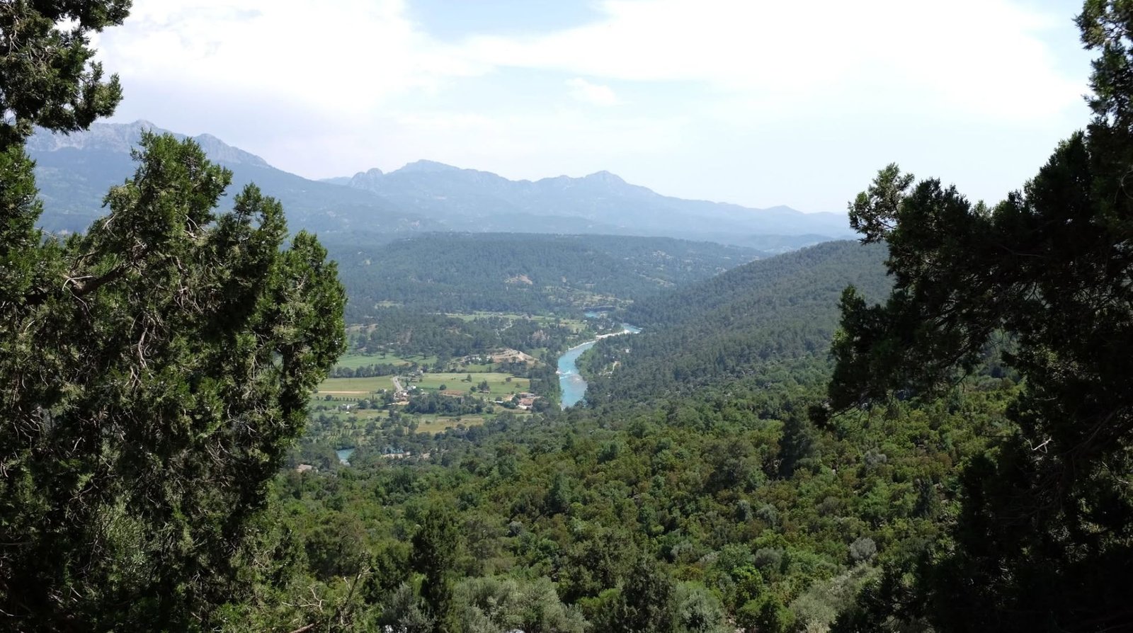
    Located approximately 92 kilometers northeast of Antalya, Koprulu Canyon National Park is one of Turkey’s most spectacular natural reserves and a paradise for outdoor enthusiasts. Covering more than 360 square kilometers (36,000 hectares), the park is renowned for its dramatic limestone canyon, crystal-clear rivers, ancient Roman bridges, dense Mediterranean forests, and exceptional biodiversity.

    The journey begins near the villages of Taşağıl and Beşkonak, where a scenic mountain road winds through pine and cedar forests, crossing sparkling streams and offering breathtaking panoramic views at every turn. The drive itself is an unforgettable experience, revealing the untouched beauty of Turkey’s Taurus Mountains.

    A Canyon of Extraordinary Beauty

    The heart of the national park is the magnificent Koprulu Canyon, carved over thousands of years by the emerald waters of the Köprüçay River. Stretching approximately 14 kilometers, the canyon reaches depths of nearly 400 meters, creating one of the most dramatic landscapes in the Mediterranean region.

    Towering limestone cliffs, lush vegetation, and the constantly flowing river provide an ideal habitat for a wide variety of wildlife and native plants. Visitors may encounter:

    • Mediterranean pine forests
    • Cedar and cypress trees
    • Wild orchids and aromatic herbs
    • Mountain goats
    • Foxes
    • Wild boars
    • Eagles and hawks
    • River trout and freshwater fish

    The park’s remarkably clean environment has made it one of Turkey’s most important protected natural areas.

    The Koprucay River

    Flowing through the canyon, the Koprucay River is famous for its crystal-clear turquoise waters, fed by underground springs from the Taurus Mountains. Besides shaping the canyon, the river supports a rich ecosystem and provides excellent opportunities for outdoor recreation.

    Today, Koprucay is internationally recognized as one of Turkey’s premier destinations for:

    • White-water rafting
    • Canoeing
    • Kayaking
    • River trekking
    • Swimming
    • Fishing
    • Nature photography

    Its combination of gentle stretches and exciting rapids makes it suitable for both beginners and experienced rafters.

    Historic Roman Bridges

    One of the park’s most remarkable historical landmarks is the Oluk Bridge. Built during the Roman period, this impressive stone bridge has stood for nearly two thousand years and still spans the canyon today. Constructed with extraordinary engineering skill, it remains one of the finest surviving Roman bridges in Anatolia.

    Nearby is the equally historic Büğrüm Bridge, crossing the Kocadere Stream. Together, these bridges illustrate the sophistication of Roman engineering and the strategic importance of this ancient route.

    White-Water Rafting Capital of Turkey

    Koprulu Canyon has become Turkey’s most popular destination for white-water rafting. Every year thousands of visitors enjoy guided rafting trips through the canyon’s exhilarating rapids and peaceful stretches.

    Adventure activities include:

    • White-water rafting
    • Kayaking
    • Canoeing
    • Ziplining
    • Jeep safaris
    • Mountain biking
    • Hiking
    • Camping
    • Rock climbing

    Professional rafting operators provide equipment and instruction, making the experience accessible even for first-time visitors.

    Hiking and Nature Walks

    Numerous trails lead through fragrant pine forests, riverside landscapes, and elevated viewpoints overlooking the canyon. Hiking routes range from easy walks to more challenging mountain treks, offering opportunities to discover the park’s rich flora, wildlife, and geological formations.

    Spring and autumn are particularly rewarding seasons, when wildflowers bloom and temperatures are ideal for outdoor exploration.

    Ancient City of Selge

    One of the park’s most rewarding excursions is to the ancient Selge, perched high in the Taurus Mountains. Founded by the Pisidians and later flourishing under Roman rule, Selge boasts an impressive archaeological heritage, including:

    • A remarkably preserved Roman theater
    • Ancient city walls
    • Temples
    • Agora remains
    • Cisterns
    • Necropolis
    • Panoramic mountain views

    Its remote location has helped preserve its authentic atmosphere, making it one of southern Turkey’s lesser-known archaeological treasures.

    Dedegöl Mountains

    Nature enthusiasts can also venture into the nearby Dedegöl Mountains, where rugged peaks, alpine meadows, caves, and pristine forests provide outstanding opportunities for hiking, mountaineering, camping, and wildlife observation.

    Dining by the River

    Scattered along the banks of the Köprüçay River are numerous traditional restaurants built on wooden platforms above the flowing water. Visitors can enjoy fresh local specialties while listening to the soothing sound of the river.

    Popular dishes include:

    • Grilled trout
    • Fresh river fish
    • Mixed Turkish meze
    • Gözleme (traditional stuffed flatbread)
    • Grilled meats
    • Seasonal salads
    • Turkish tea served beside the river

    Best Time to Visit

    • Spring (April–June): Ideal for rafting, hiking, and enjoying lush green landscapes.
    • Summer (June–September): Perfect for rafting, swimming, and outdoor adventures, with the cool river providing relief from the heat.
    • Autumn (September–October): Pleasant temperatures, vibrant colors, and fewer crowds.
    • Winter: Quiet and scenic, suitable for photography and peaceful nature walks.

    Why Visit Köprülü Canyon National Park?

    Köprülü Canyon National Park is one of Turkey’s finest destinations for both adventure and relaxation. Its towering canyon walls, emerald river, ancient Roman bridges, rich biodiversity, and nearby archaeological treasures create an unforgettable combination of natural beauty and cultural heritage. Whether you’re rafting through thrilling rapids, hiking forest trails, exploring the ancient city of Selge, or enjoying fresh trout beside the river, Köprülü Canyon offers one of the most rewarding outdoor experiences on the Turkish Riviera.

  • Ozkonak Underground City – carved into the volcanic tuff of Mt. Idis

    Ozkonak Underground City – carved into the volcanic tuff of Mt. Idis

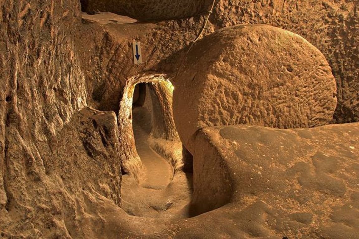
    Ozkonak Underground City is one of Cappadocia’s most intriguing underground settlements, located approximately 14 km northeast of Avanos. Built beneath the northern slopes of Mount İdis, this remarkable underground city was carved into layers of volcanic tuff and granite-like volcanic rock, creating a vast subterranean refuge for ancient communities.

    Although less famous than Derinkuyu Underground City and Kaymakli Underground City, Ozkonak is unique for its innovative defensive features and more spacious tunnel system, making it one of the most interesting underground cities to explore in Cappadocia.


    History and Discovery

    Ozkonak remained hidden beneath the earth until 1972, when local farmer and muezzin Latif Acar discovered a mysterious underground chamber while investigating where water used to irrigate his crops was disappearing.

    Further excavations revealed an extensive underground settlement consisting of interconnected rooms, tunnels, storage chambers, ventilation shafts, and defensive structures. Archaeologists uncovered a city that could shelter thousands of inhabitants during times of danger.

    Today, ten levels are believed to exist, extending to a depth of approximately 40 meters below ground, although only four levels are currently accessible to visitors.


    Architecture and Engineering

    The underground city was designed to provide safety, ventilation, communication, and long-term survival during invasions.

    Tunnel Network

    A complex system of galleries and passageways connects living quarters, communal spaces, storage rooms, and defensive sections throughout the city.

    Ventilation System

    Unlike many underground settlements, Ozkonak contains highly efficient ventilation shafts that provided fresh air throughout the complex even when entrances were sealed.

    Communication Holes

    Long vertical shafts between levels allowed residents to communicate with each other and transport supplies between floors without exposing themselves to danger.

    Water Supply

    A sophisticated well system provided fresh water for inhabitants, enabling extended periods of underground habitation.

    Winery and Storage Rooms

    Special chambers were used for storing grain, food, wine, and other necessities required for long stays underground.


    Unique Defensive Features

    One of the most remarkable aspects of Ozkonak is its advanced defense system.

    Rolling Stone Doors

    Like other Cappadocian underground cities, enormous circular stone doors could be rolled into place to block tunnels and prevent enemy access.

    Defense Holes Above Tunnels

    Ozkonak features a rare security system not commonly found elsewhere in Cappadocia. Small openings positioned above passageways allowed defenders to attack invaders by dropping stones, spears, or even hot oil through the shafts.

    These features made the underground city exceptionally difficult to penetrate.


    What to See

    Main Entrance Galleries

    The entrance tunnels offer a fascinating introduction to the underground world beneath Cappadocia.

    Living Chambers

    Explore rooms that once housed families seeking refuge during periods of conflict.

    Food Storage Areas

    Large storage spaces reveal how communities survived underground for extended periods.

    Ventilation Shafts

    Observe the engineering techniques that kept air circulating throughout the city.

    Winery

    Discover evidence of Cappadocia’s ancient wine-making traditions.

    Defensive Corridors

    See the unique security features that distinguish Ozkonak from other underground settlements.


    Things to Do

    • Explore the underground tunnels and chambers.
    • Learn about ancient defensive engineering.
    • Photograph the city’s fascinating architecture.
    • Join a guided historical tour.
    • Compare Ozkonak with Kaymaklı and Derinkuyu.
    • Visit nearby Cappadocian valleys and villages.

    Nearby Attractions

    Avanos

    Known for pottery workshops, ceramics, and the scenic Kızılırmak River.

    Zelve Open Air Museum

    An abandoned cave settlement showcasing Cappadocia’s unique rock-cut architecture.

    Çavuşin

    A historic village with cave dwellings and ancient churches.

    Göreme

    The heart of Cappadocia tourism and gateway to famous hot-air balloon flights.

    Göreme Open Air Museum

    A UNESCO World Heritage Site featuring Byzantine frescoed churches.

    Kaymaklı Underground City

    One of Cappadocia’s largest underground settlements.

    Derinkuyu Underground City

    The deepest underground city in the region.


    Tours and Excursions

    Cappadocia Red Tour

    Many organized tours include:

    • Ozkonak Underground City
    • Avanos pottery workshops
    • Zelve Open Air Museum
    • Devrent Valley
    • Pasabag (Monks Valley)

    Underground Cities Tour

    Explore several subterranean settlements to better understand Cappadocia’s unique underground civilization.

    Cultural Heritage Tours

    Combine visits to underground cities with cave churches, valleys, and traditional villages.


    Food and Drink

    Nearby Avanos offers excellent opportunities to sample traditional Cappadocian cuisine.

    Popular local specialties include:

    • Testi Kebabı
    • Mantı
    • Gözleme
    • Local lamb dishes
    • Cappadocian wines
    • Turkish tea and coffee

    Visitor Information

    Best Time to Visit

    • Spring (April–May): Ideal weather and beautiful landscapes.
    • Autumn (September–October): Comfortable temperatures and excellent sightseeing conditions.
    • Summer: Cooler underground temperatures provide relief from the heat.
    • Winter: Fewer visitors and magical snow-covered Cappadocian scenery.

    Duration

    Most visits take between 1 and 1.5 hours.

    What to Bring

    • Comfortable walking shoes
    • Light jacket
    • Camera
    • Drinking water

    Accessibility

    Some passages are narrow and involve stairs. Visitors with mobility limitations or claustrophobia should take this into consideration.


    Why Visit Ozkonak?

    Ozkonak Underground City offers a fascinating glimpse into one of humanity’s most ingenious survival strategies. Its unique defensive systems, spacious galleries, and remarkable engineering make it one of the most distinctive underground cities in Cappadocia. Combined with nearby attractions such as Avanos, Zelve, Göreme, and Cappadocia’s famous fairy chimneys, Ozkonak is an essential stop for travelers interested in archaeology, history, and the extraordinary cultural heritage of central Turkey.

  • There is no need for any experience or training to do rafting

    There is no need for any experience or training to do rafting

    Turkey is one of the world’s emerging destinations for adventure tourism, offering spectacular landscapes, pristine rivers, and unforgettable outdoor experiences. As interest in nature-based tourism continues to grow, environmentally friendly sports have become increasingly popular among travelers seeking excitement while preserving the natural world. Among these activities, rafting stands out as one of the most thrilling and rewarding adventures.

    Combining teamwork, physical endurance, strategy, and a deep connection with nature, rafting allows participants to challenge powerful river currents while experiencing some of the most beautiful and untouched landscapes on Earth.

    The Spirit of Rafting

    Human beings have always been fascinated by rivers. For thousands of years, rivers have provided water, transportation, food, and inspiration for civilizations. Today, they also offer adventure seekers the opportunity to test their skills against one of nature’s most powerful forces.

    Modern rafting is practiced using inflatable boats made from durable materials and typically accommodates groups of four to twelve participants. Success depends not only on physical strength but also on teamwork, coordination, quick decision-making, and mental resilience.

    Equipped with life jackets, helmets, and paddles, rafters navigate turbulent waters, powerful rapids, and challenging river passages. The sense of accomplishment that comes from conquering a river’s wild currents and reaching the finish point is one of the sport’s greatest rewards.

    Beyond the excitement, rafting offers participants a unique opportunity to explore remote landscapes, hidden valleys, dramatic canyons, and untouched natural environments that are often inaccessible by other means.

    Rafting and Sustainable Tourism

    One of rafting’s greatest advantages is its minimal environmental impact. Unlike many tourism developments that require extensive construction and infrastructure, rafting relies primarily on natural waterways and responsible outdoor recreation.

    As a result, rafting promotes:

    • Nature conservation awareness
    • Sustainable tourism development
    • Protection of river ecosystems
    • Local economic growth
    • Environmentally responsible travel

    For this reason, rafting has become an important component of Turkey’s adventure tourism industry.

    Turkey’s Best Rafting Rivers

    Turkey is blessed with numerous rivers suitable for rafting, kayaking, and canoeing. Some of the country’s most famous rafting destinations include:

    Black Sea Region

    • Coruh River
    • Firtina River
    • Berta River
    • Barhal River
    • Oltu River
    • Harsit River

    Mediterranean Region

    • Goksu River
    • Koprucay River
    • Manavgat River
    • Dragon River
    • Cehennem Stream

    Among all these rivers, the Coruh River is widely considered Turkey’s premier rafting destination and one of the world’s most exciting white-water rivers.

    Rafting on the Çoruh River

    Flowing through the dramatic landscapes of northeastern Turkey, the Coruh River is internationally recognized as one of the fastest-flowing rivers in the world and one of the finest rafting destinations in Europe.

    Originating in the Mescit Mountains at an elevation of approximately 3,225 meters, the river travels nearly 466 kilometers before crossing into Georgia and eventually reaching the Black Sea.

    Its powerful currents, steep canyons, and breathtaking scenery attract rafting enthusiasts, kayakers, trekkers, and nature lovers from around the globe.

    A Valley Rich in Nature and Culture

    The Coruh Valley is not only an adventure destination but also a region rich in cultural heritage and natural beauty.

    Picturesque villages and small towns line the riverbanks, preserving centuries-old traditions and showcasing a unique blend of Eastern Anatolian and Black Sea cultures.

    The surrounding mountains, forests, and alpine landscapes create one of Turkey’s most spectacular natural environments.

    The Kackar Mountains

    Many visitors combine rafting with trekking in the magnificent Kackar Mountains, one of Turkey’s most important mountain ranges.

    Popular access points include:

    • Yaylalar Village
    • Olgunlar Village
    • Dilberduzu Camp Area

    Dilberduzu serves as an excellent base camp for climbers attempting to reach the summit of Kackar Mountain, which rises to approximately 3,937 meters above sea level.

    Local guides and pack animals are available for hire, making the area accessible to a wide range of visitors.

    Exceptional Wildlife

    The Coruh Valley remains one of Turkey’s most pristine natural habitats.

    The region supports an extraordinary variety of wildlife, including:

    Mammals

    • Brown bears
    • Mountain goats
    • Wild boars
    • Wolves
    • Jackals
    • Foxes
    • Badgers
    • Martens
    • Hares

    Birds

    • Red vultures
    • Golden orioles
    • Partridges
    • Wild ducks
    • Woodcocks
    • Doves
    • Pigeons
    • Various migratory bird species

    The cliffs along the river are particularly important nesting sites for rare and endangered birds of prey.

    The Classic Coruh Rafting Route

    The traditional rafting expedition follows approximately 260 kilometers of river from Bayburt through Ispir and Yusufeli to Artvin.

    Bayburt – Ispir (0–106 km)

    The journey often begins near Dikmetaş Bridge outside Bayburt.

    Highlights

    • Ideal camping locations
    • Gentle to moderate rapids
    • Scenic mountain landscapes
    • Suitable introduction to the river

    Difficulty Level

    Class II–III

    Average Duration

    Approximately three days

    Popular campsites include:

    • Dikmetas Bridge
    • Aslandede
    • Laleli

    Camping areas are available near İspir for overnight stays and resupplying.

    Ispir – Camlikaya (106–134 km)

    This section introduces more technical rapids and stronger currents.

    Difficulty Level

    Class III–V

    Highlights

    • Challenging white water
    • Mountain scenery
    • Riverside camping areas
    • Freshwater springs

    The route requires greater experience and careful navigation.

    CamlIkaya – Tekkale (134–178 km)

    As the river flows onward, fertile agricultural landscapes appear along the banks.

    Visitors pass:

    • Rice fields
    • Fruit orchards
    • Vegetable gardens
    • Traditional villages

    Difficulty Level

    Class III–V

    Attractions

    • Historic watchtowers
    • Village culture
    • Trout fishing opportunities
    • Medieval Georgian churches

    One notable excursion is the historic Dört Kilise (Four Churches), an important medieval Georgian religious complex located in the mountains above Tekkale.

    Tekkale – Artvin (178–261 km)

    This is the most demanding and exhilarating portion of the expedition.

    Near Yusufeli, several tributaries join the Coruh, significantly increasing water volume and speed.

    Difficulty Level

    Class III–V+

    King Kong Rapid

    The most famous section of the river is the legendary “King Kong” rapid.

    This approximately 100-meter stretch features:

    • Massive waves
    • Powerful currents
    • Sharp boulders
    • Extremely fast-moving water

    Rated Class V+, King Kong is considered one of the most challenging white-water rapids in Europe and should only be attempted by experienced rafting teams under appropriate conditions.

    Final Canyon Section

    Near Artvin, the river enters a dramatic canyon approximately three kilometers long before gradually calming toward the end of the route.

    International White-Water Classification System

    Rafting rivers are classified according to their level of difficulty.

    Class I

    Easy water with small waves and minimal obstacles.

    Class II

    Moderate rapids with straightforward routes and occasional rocks.

    Class III

    Strong currents, larger waves, and technical maneuvers requiring experience.

    Class IV

    Powerful rapids with unpredictable conditions, dangerous rocks, and demanding navigation.

    Class V

    Extremely difficult rapids featuring high-speed currents, large drops, and significant hazards.

    Class VI

    Considered virtually impassable and suitable only for expert exploration under exceptional circumstances.

    Essential Safety Guidelines

    Safety is the most important aspect of rafting.

    Participants should always:

    • Wear approved life jackets
    • Use protective helmets
    • Wear suitable river shoes
    • Follow guide instructions carefully
    • Paddle as part of a coordinated team
    • Understand river conditions before departure

    Protective eyewear and additional safety equipment may also be recommended depending on weather and river conditions.

    Organized Rafting Tours

    Because rafting involves technical challenges and safety considerations, participants are strongly encouraged to join professionally organized tours operated by licensed adventure tourism agencies.

    Professional guides provide:

    • Safety briefings
    • Technical instruction
    • Equipment
    • River navigation expertise
    • Emergency support

    This ensures both a safer and more enjoyable rafting experience.

    The Great Adventure of Turkey

    From the roaring rapids of the Coruh River to the scenic waterways of the Mediterranean and Black Sea regions, rafting in Turkey offers an unparalleled combination of adventure, natural beauty, and cultural discovery.

    Whether you are an experienced white-water enthusiast or a first-time adventurer, Turkey’s rivers provide unforgettable experiences that combine excitement, teamwork, and a deep appreciation for nature. For those seeking the ultimate outdoor challenge, rafting on the Coruh River remains one of the most thrilling and rewarding adventures in the country.